Shifting Winds Lead to Cotopaxi Summit

Cotopaxi Summit
Cotopaxi Summit

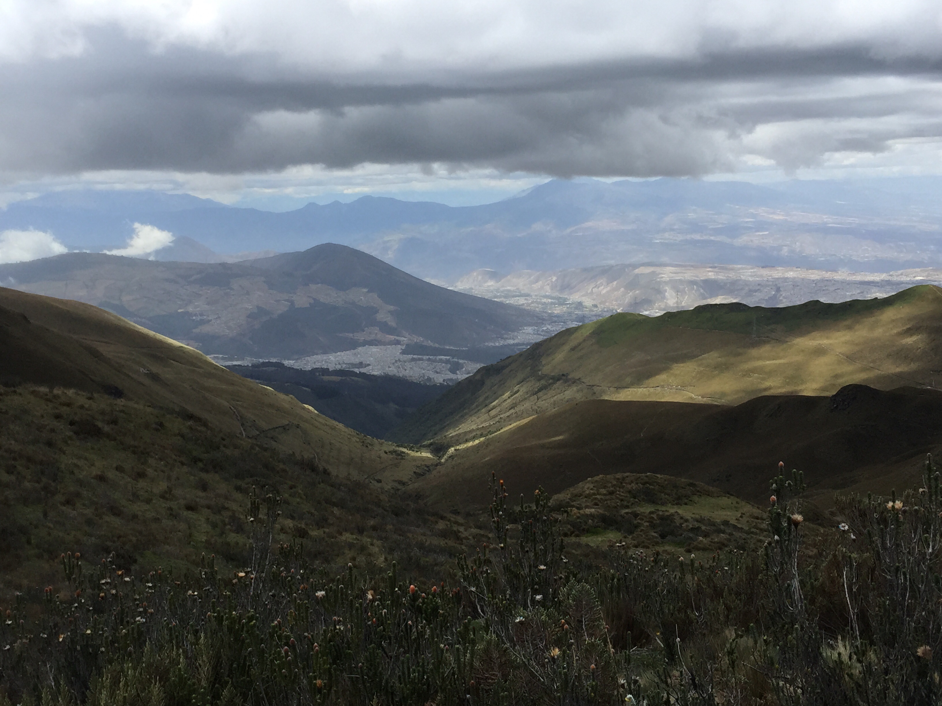
The wind shifted. I’ve always known the wind is important. After all, Mary Poppins arrived with the east wind, and there’s an old saying that if you make a face when the wind changes your face will get stuck that way. But I’d never really experienced just how important a shift in the wind could be until we were right at the lip of the Cotopaxi crater, just below the summit.

After climbing Illiniza Norte, we spent the night at the Hacienda Chilcabamba. I went to bed at 6:30 and slept for about 12 hours – unable to face anything for dinner. I felt about a hundred times better the next day, and we had an easy morning at the hacienda, followed by a large lunch. J and I had a little thatched cottage all to ourselves, with two bedrooms and a sitting area, heated by a wood stove.

Hacienda Chilcabamba

We left in early afternoon to drive to the parking lot for the Cotopaxi hut. This time I sat in the front seat to avoid the  gastrointestinal dangers associated with the curving cobbled stone roads. From the parking lot we strapped on our backpacks, which contained only what we needed at the hut and for our summit attempt. We were already wearing our base layers, to minimize having to change. The walk up to the hut is about 45 minutes on a steep dirt road – we reached the top, only for Ossy to realize he’d left his phone in the car and had to go down to get it!

The Cotopaxi hut was redone only a few months ago, and although nicely varnished and with new mattresses, it’s really cold and the roof makes an incredible array of noises in the whistling wind. While the Illiniza Norte roof clanged and sounded as though it might blow off, this roof variably screamed, whistled, hooted and howled. Despite all that, after we’d had bowls of quinoa soup, followed by figs, cheese and sweet biscuits, we still managed to sleep a few hours.

Bedroom at the hut at Cotopaxi

We were supposed to awaken at 11:30 pm but  slept through the alarm and ended up getting up at midnight. Just as on Illiniza Norte, we were the only people in the hut.  And we soon found out there were only two other climbers on the entire mountain, besides us.

We stuffed some food into ourselves and started climbing about 1 am. The first part is a 45 minute walk up a relatively steep scree field. Once at the top, you’re on the glacier, which meant it was time to rope up and put on crampons.
The old “normal” route has been closed for 2 or 3 years after a climber was killed on it – too many crevasses. Instead you now use the Rompe Corazones – the heartbreaker. There’s an extremely long 2 plus hour stretch that simply goes up without any sort of break. And it’s a killer. I was trying hard to stay hydrated, so each hour when we stopped, the routine was water, a handful of trail mix, and more water. As we gained altitude, the trail mix became GU, and Ossy was literally tearing the top of the packages and holding them as I sucked the sticky sweet electrolytes out.

We climbed up one sheer icy patch where we had to use the front points of our crampons – as if we were scaling a vertical wall.  Much of the trek up was simple side by side steps, but even there I kept finding my crampons pointing too far uphill, and I quickly realized how much I had to learn in the way of technique.

Sea of Penitentes
Sea of Penitentes

At one point you traverse a sea of Penitentes – formed by the wind, they are peculiar to the Andes in the summer months. Sometimes they are upright, but these were bent by the wind. They look like a field of praying hands, fingers outstretched in supplication. You can walk between or on them, and if on, each step sounds as though you are stepping on a brittle twig – or finger.

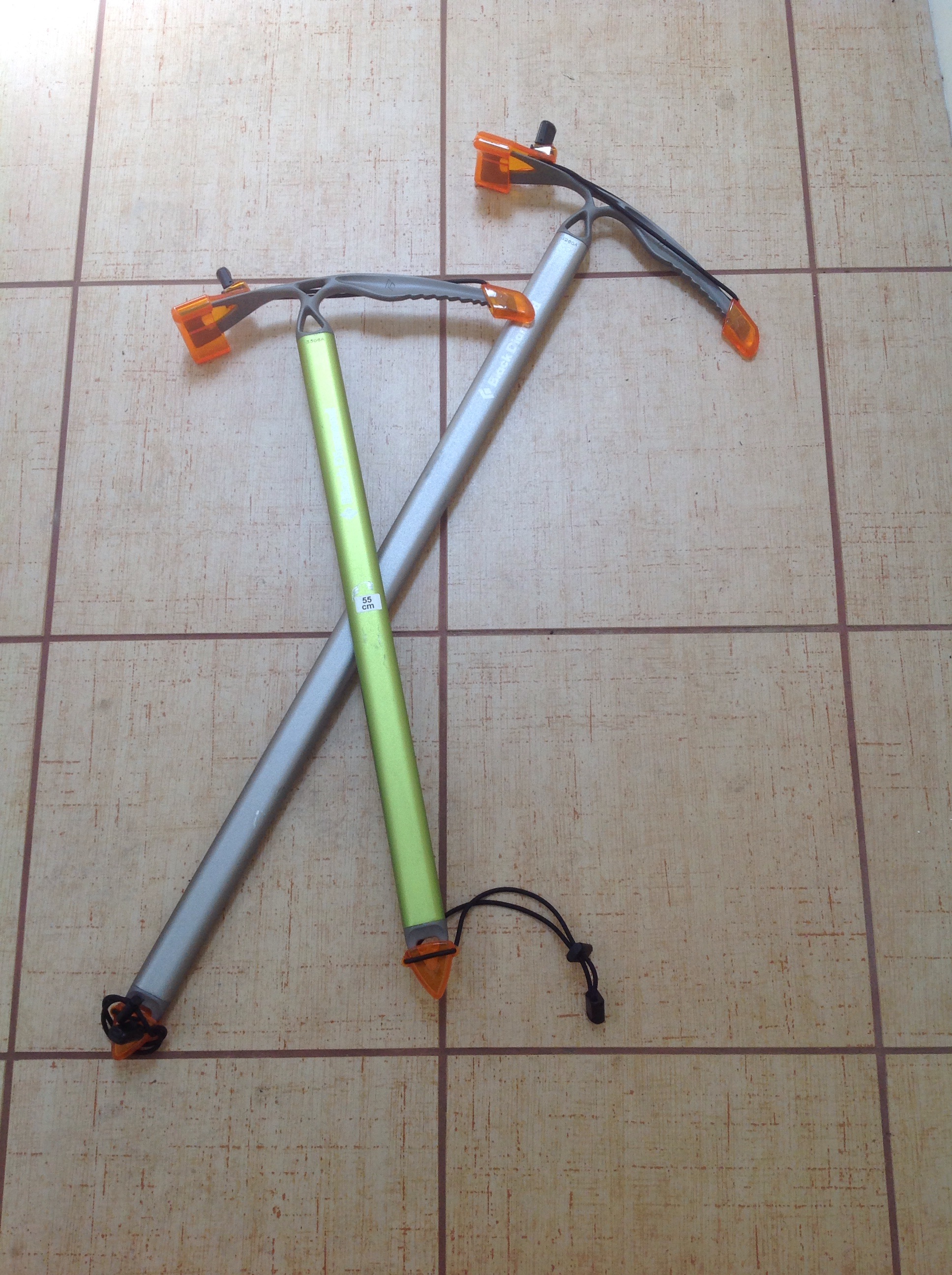
The very last bit of Cotopaxi is steep, steep, steep. As we had to do in a couple of prior areas, we used the picks of our ice axes overhand to dig in and help pull ourselves up (normally you’re using your ice axe in your uphill hand like a very sharp ski pole or walking stick).

But just before we reached that point, we saw the only other two climbers on the mountain turn around, apparently overwhelmed by the sulphur fumes spewing out of the crater.  You may recall I mentioned that starting in May or so Cotopaxi had reactivated. It is “degassing” (lovely word) and literally tons of fumes are forming into thick heavy clouds over the crater – which is just below the summit.

Despite the retreat of the other climbers, we kept on going. Although the mountain administered a pretty strong dose of sulphur to us – Ossy and J in their throats and me in my eyes – just at that point….the wind shifted. I heard Ossy say that we might have a window and I kept slogging up the close to vertical slope.

Suddenly I was on a flat area – but surely I couldn’t be there. I was positive there must be another 15 or more minutes of sheer physical and mental pushing left and this was just a fake….but no, I was actually at the summit. There wasn’t anywhere else up to go. I’d seen people on YouTube videos throw themselves down on the ground when they finally arrived, and without even thinking, that’s just what I did too.

Cotopaxi Summit - sulphur cloud in background
Cotopaxi Summit – sulphur cloud in background

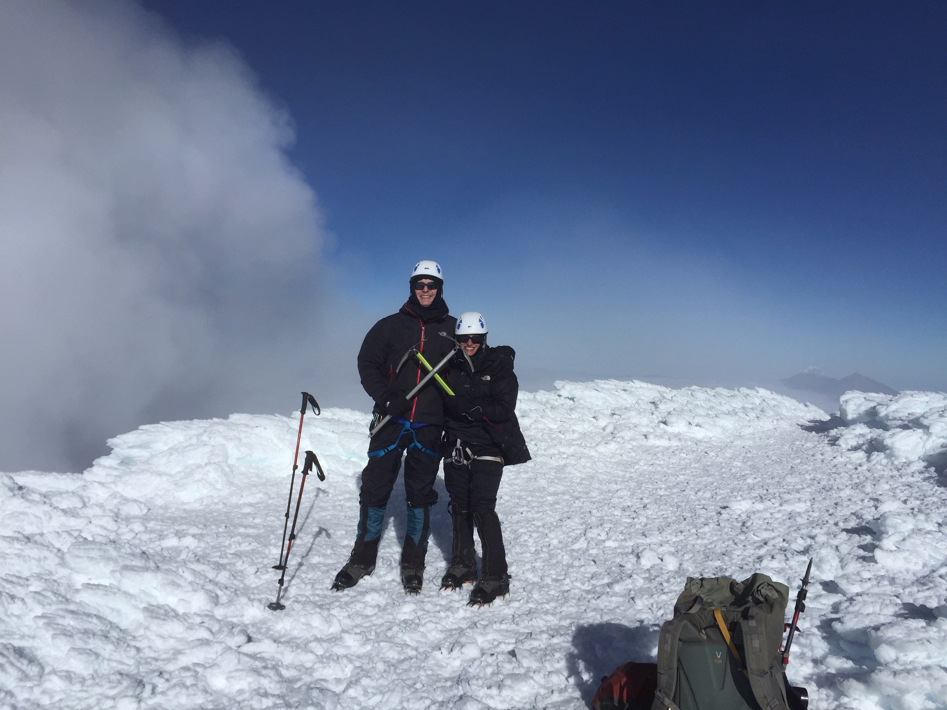
We couldn’t stay on the summit for long – just in case the wind shifted again and the crater drenched us with another load of sulphur.

Our descent was noneventful, which is about the best that can be said about descents. We kept up a pretty good pace, with J on the front of the rope, me in the middle, and Ossy bringing up the rear in order to arrest whoever might fall.

It turned out we made it up in 6 hours and 50 minutes, well within the range of normal, and down in 3 hours – also what Ossy wanted us to do.

Once back at the hut the reality of what we had just accomplished finally sank in. All those stairs; all those hot and sweaty runs.  The culmination of all of it was that confluence of ice and snow and blue sky. A perfect summit.

Illiniza Norte Or How I Ended Up Rock Climbing After All

Cotopaxi from the hut at Illiniza Norte

Some of you may remember that one reason we ended up in Ecuador instead of the Grand Teton was our conclusion that we preferred mountaineering to rock climbing. (See “Cotopaxi, Ecuador – 180 Degree Turns.”)  So it was somewhat inexplicable that I nonetheless found myself on July 1 hanging on for dear life to an ice encrusted basalt wall with my left hand, ski pole in my right and nothing but an almost vertical drop of rocks below. Oh, and this was at about 16,000 feet. And did I mention no ropes?

Illiniza Norte is one of the two Illiniza peaks (the other, obviously, is Sud), and is a common acclimatization hike in preparation for Cotopaxi. It reaches about 16,500 feet, and is the taller of the two forked peaks in the right in the photo. Its sister peak, on the left, is much more technical and is covered in snow.

The Illiniza Peaks
The Illiniza Peaks

It was about a three hour hike to the mountain hut where we were to stay for our ascent of Illiniza Norte so we left in early morning. After fighting through Quito traffic, we followed modern highways for a while until we abruptly turned off to cobble stone roads, still in the same condition as in the 1940s when Ossy thought they were originally built. Jaw breaking and winding is an understatement. More on that later.  We passed through several small villages, stopping at one to drop off things we wouldn’t need on the hike. Once we parked the car near the trailhead, we met up with the two men who took our supplies up to the hut on horses. Each day the horses plod up to the hut with full loads and bring trash back.  Despite the routine, they seem quite content with their rather proletariat role in life.
image
The mountain hut is primitive – but there are flushing toilets, even if you do have to go outside to get to them. There’s a series of about four bunk beds, going up to a triple level, a small eating area and a tiny kitchen. No electricity. We were the only people there, and, in fact, the only climbers on the mountain the next day. That night we were treated to a spectacular sunset with a full moon. The entire Avenue of Volcanoes was visible, including the white capped isosceles triangle of Cotopaxi.

We got up at 5 for an early morning departure. The weather cleared as we hiked. There was more snow than normal, and many of the rocks were encrusted with icicles. I was glad of my climbing helmet since I hit my head several times on wide swathes of ice sticking out from the rocks I was trying to hold on to.

There are several sections of rock, the most difficult probably the one right below the summit. We climbed up through a chimney, along exposed ledges – and all without ropes. Ossy very carefully instructed where to place hands and feet and how to balance – and ultimately we did make it to the summit which is marked by a metal cross. But that wasn’t before a bowling ball sized rock hurtled down from the top in J’s general direction, followed by a smaller one in his more specific direction. Fortunately, no injuries. We now know the best way to react to rockfall (besides not experiencing it in the first place!) is to make yourself as small as possible. Sort of an airline crash position.

Summit of Illiniza Norte - that's the summit cross that appears to be sticking out of my head
Summit of Illiniza Norte – that’s the summit cross that appears to be sticking out of my head

Coming down was exhausting and Ossy roped me in after I slipped twice. I think I’d burned up a lot of nervous energy on the ascent – not to mention physical. And we not only had to descend and get back to the hut – there was still the three hour hike back to the parking lot ahead of us, and then a couple of hours to drive to our next stop, the Hacienda Chilcabamba, outside Cotopaxi National Park.

For someone who actually froze on the stairs of the Eiffel Tower and who still has recurring dreams about being stuck on the old swinging bridge on Grandfather Mountain in North Carolina, reaching this summit was huge. But it also reminded me that figuring out how to get down from summits is just as important as going up them.

Rucu Pichincha, Ecuador – Rocks and Ridges

Rucu Pichincha - the paramo
Rucu Pichincha – the paramo

On June 29, 2015, at 8:15 am, J, I and our guide, Ossy, left the Hacienda Rumiloma on the outskirts of Quito for Rucu Pichincha. Reminiscent of Mt. Elbrus, you travel up the first section by way of gondola. The gondola was constructed in 2005 as part of an ambitious amusement park, restaurant and hotel complex that failed not long after it opened. The gondola is all that really survived and it’s a bit depressing to see the closed shop fronts below.

Mountain hikes here start in the paramo – the Ecuadorian highlands. Wild flowers abound – white and yellow daisies that grow flat to the ground, violets, red bell shaped flowers, yellow blooms on bushy shrubs about waist high. Parts of the hike were like walking on a carpet of flowers.
image
As we neared the summit, there was some class 4 and 5 scrambling – using your hands as you scale the tumbled down rocks. The summit was spectacular. I never feel as totally in the present as on a summit.

J and Ossie on the summit of Rucu Pichincha
J and Ossy on the summit of Rucu Pichincha

Going down was fun. We learned to down climb – facing the rocks, youbcontinuously look down for your next step, as though you’re on a ladder. It was surprisingly similar to the backward stair climbing I had practiced so diligently as part of my training. (I tried to do that part in flights I knew I was the least likely to encounter other people.) The rest of the trail down was runnable – that fantastic feeling of flying where you gather just enough momentum to take you up the next uphill bit.

Of note, as we neared the parking lot we ran into the Climbing 4 My Donor group from the UK – a group of heart- lung transplant patients whose Twitter feed I had been following. So impressive. They had just climbed Rucu, were planning on Ilianza Norte and were substituting Cayambe for Cotopaxi due to the level of sulphur.

We spent another night at Rumiloma and then it was off to Illiniza Norte – our experiences in climbing up Class 5 rock without ropes, the rock that almost hit J and our first mountain hut to be posted shortly. As a preview – sunset from the hut at Illiniza Norte.

[Sunset from the hut in Illiniza Norte Sunset from the hut at Illiniza Norte

Quito – The Kick Off

Hacienda Rumiloma, Quito, Ecuador
Hacienda Rumiloma,
Quito, Ecuador

Writing from the Hacienda Rumiloma in Quito, where one of the resident peacocks has just perched outside our window. We are in a beautiful large room, filled with antiques and a bathroom with an elaborately tiled sunken tub and a view into the cloud forest. The property on which the hacienda is located has been in our guide’s family for a hundred years. It’s minutes outside of Quito – up tremendously steep hills that are lined with apartments, bodegas, small restaurants and many people, all outside enjoying a beautiful day.

The hacienda is at almost 11,000 feet and we could feel the altitude last night when we arrived after dark. The airport is about an hour from Quito – despite the pilot’s dire warnings of turbulence the descent wasn’t too bad. But it was a bit disconcerting to land looking up at the sides of the mountains.

Today we spent touring the old city of Quito. We started with the Virgin of Quito – an enormous winged Virgin Mary, who is stepping on a serpent, a gift from Spain in 1946. image

From there we wandered with our guide, Ossie, through various squares and side streets, and once mass had ended visited the gold encrusted Iglesias de la Campana de Jesus. It’s a baroque-style church, every inch of which is covered by carvings with 18 karat gilt pressed into their surface. The ornamentation is so geometric that were it not for chapels dedicated to multiple saints lining the sides you could almost be in a mosque.

We had lunch at an Ecuadorian restaurant, lots of corn, potatoes, pork, with Ossie and his charming wife and one of his teenaged daughters (who will be in Boston soon on summer science scholarship) – and enjoyed hearing their stories of a six month stay in the deep Amazon jungle.

Then it was off to the Equator line that divides the northern and southern Hemispheres. Funny how until then it never occurred to me that Ecuador is so named because of the equator.

We’ve just returned to the hotel and Ossie checked out equipment. We mostly passed. Tomorrow will be our first acclimatization climb. Instead of Gua Gua Pichincha, due to wind patterns we will be climbing Rucu Pichincha (means shiny). It’s about 15,696 feet high and should be a six hour round trip.

So the climbs are about to begin. Right now they are filming a movie or doing some sort of photo shoot outside my window. There’s a yellow VW bus, sunflowers on the dashboard, decorated with “just married” regalia. A bride and groom are sitting atop the van. Not sure what it all signifies, but it has to be a good omen!

Almost En Route to Ecuador

image

Florida has treated us to some spectacular lightning strikes the last few days – cloud to earth vertical forks so brilliant I was actually blinded when driving on I-4 the other day. I’m hoping they aren’t a portent for our upcoming trip to Ecuador’s Avenue of Volcanoes. It is true that Cotopaxi, which is the highest active volcano in the world, has started to show signs of activity. While I have read that an eruption is not considered imminent, the mountain is degassing, letting off five times the normal amount of sulphur. So, we can add that to the obstacles we’ll have to contend with. I suppose there’s a chance that the mountain could be dicey enough that it is closed to climbers – but there are plenty of other mountains in Ecuador – not to mention the highest peak, Chimborazo, which we are already scheduled to climb. And at least it is a dead volcano.

So when I’m not scouring the Internet with search terms like “latest volcanic activity on Cotopaxi,” husband J and I are in the throes of last minute gear assembly and packing for Saturday’s departure on Copa Air. Our to do list includes items such as “cut 60 feet of rope into two 30 feet lengths,” buy GUs (for me) and those square gel energy things (for J), and “locate long underwear” (it’s amazing how things can get lost in a not particularly large house).

I have also reached that blessed moment where I feel I can finally taper back on the training. I had my “PR” – to use a term of all you Crossfit people out there – on the stairs last week, 9 times up and down the building with a 25 pound pack.  I may do more stairs but without the weight, as the pack is soon to be filled with climbing gear. And any really long runs are coming to an end just in time – because I’ve discovered that running in 90 degree heat and 90 percent humidity is no fun and certainly does nothing good for your splits (times for each mile).

As these months of training draw to a close and the days of packing ensue – all I can hope is we’ve done what it will take. And equally important pray that the volcano and mountain gods will look kindly upon these poor mortals as they venture up.

Things That Can Go Wrong on the Way From the Swamp to the Summit

Tempting fate - the untied shoelace
Tempting fate – the untied shoelace

It began yesterday. For those of you who are regular readers of this blog, I’m pretty sure I recounted our August 2012 climb up Mauna Kea, which only occurred because husband J managed to contract one of the few cases of out of season flu in the state of Hawaii, thus putting the kabosh on our plan to backpack the Mulawai trail.  I didn’t think something like that could possibly happen again. But yesterday, J announced to me that for a week he’s seen cobwebby things in his left eye, initially accompanied by a flash of light. Now, the only time I’ve heard of “floaters” (J keeps calling them floaties, like the water wings your kids wear when they’re four years old) involves detached retinas, laser surgery and possible blindness.

So, rather than google “floaters,” we – of course – researched retinal detachment, only to discover the surgical repair involved a healing period that would greatly cut into our 13 days from now departure for Ecuador and the Andes. Apparently high altitude is not considered an optimum recovery spot for eye surgery.

In any event, a “quick” visit to our local optometrist today, together with full pupil dilation and photographs of the eyeball innards, reassured all concerned that these floaters were nothing more than part of the normal aging process for people in their fifties. I keep asking why no one has given us an instruction manual. We’re highly aware of the normal wear and tear on the body, but floaters? Really?

While all this was transpiring, I was facing my own Private Idaho – we have long had a pact that if one of us can’t make it up a mountain the other goes forward. And that I would have done – but the idea of scaling Cotopaxi and maybe Chimborazo with just me and a guide was definitely going to push that pact to its furthest limit. I lay awake last night thinking of the worst case scenarios – just to get my mind in gear to accept that it could conceivably be me versus the mountain. I would have done it – but it wouldn’t be optimum.

Yesterday I did a seven mile run in unbelievable heat and humidity. Now I know many of you run further, but believe me, it’s hard when it’s in the 90s at 9 am with an equal percentage of humidity. At one point I realized my shoelace was progressively getting looser and I could feel it flapping on the ground as I ran.

You know what? I actually stopped; paused my Map My Run app; and tied the damn shoelace. All the running in the world isn’t going to do me much good if I trip and break my ankle two weeks before departure.

It’s coming soon now. Please send some good karmic vibes our way.

Crossing Florida

Historical Florida
Historical Florida

The beauty of taking a road trip under the guidance of Google maps is that, Dr. Seuss-like, you’ll never guess the places you’ll go – or the things that you’ll see. And such was the case this weekend when Google maps itook us off I 4
and routed us onto Florida Road 570 and 540 – and then continued to take us down 17 South cutting across the great state of Florida – until we finally met up with I 75 near the Gulf and made our way to Naples, location of my law firm retreat.

One of my favorite parts of Google maps on this particular adventure was its insistence that we were traveling north – despite all indications to the contrary, including road signs, Google’s own moving map, and the location of the Gulf of Mexico itself ahead of us.

Living in metropolitan Central Florida it’s easy to forget that Florida still has vast swathes of rural land.  Cows graze in brownish green meadows and rest in the shade of the curtains of Spanish moss that cascade down from clusters of live oaks. The land has just a little roll to it, just enough to envision it once as the sandy floor of a lapping ocean.

image

Every few miles you happen upon yet another small town. Most of them seem to have escaped the scourge of McDonalds, Chick-Fil-A and Burger King. In fact, the one time we really only had time for fast food all we could find was slow food. The Double JJ Restaurant, the Pioneer Cafe, Smokin’ Joe’s BBQ.  It wasn’t until we returned to the interstate that the familiar chains showed up again.

image

Small town USA no longer looks like Archie Bunker’s US of A.  Smokin’Joe’s is right next to the Taqueria and the place that specializes in wiring money to Mexico.  In towns like Zolfo Springs and Bowling Green and Cleveland, the Pioneer Restaurant is across the street  from the Acapulco Cafe and the Mercadio. In the fields growing who knows what, converted school buses were busy delivering migrant farm workers to do the back breaking picking of whatever it is that we only encounter in the pleasant coolness of the produce sections in our local grocery stores.

image

After passing through Polk, Hardee and DeSoto counties, as we neared the Gulf, stucco walls surrounding golf communities started to partition the wide open spaces. The old Florida cracker tin rooves gave way to the repetitive Florida idea of Mediterranean tile. Funny how those Mediterraneans had garages as a central feature of the facade of their houses.

Despite all that nothing beats the glassy lake of the gulf or its sugar sand that was waiting for us in Naples.

We returned home the same way. We stopped to eat a quick picnic lunch in a small park across from the DeSoto County Courthouse. Somehow that seemed an appropriate way to end a law firm retreat. And what better way to prepare for the mountains of Ecuador in three weeks than to really experience the Flatlands of Florida.

DeSoto County Courthouse

Running – The World is Flat After All

image

What's up; what's down
What’s up; what’s down

As I plowed uphill on the first half of Saturday’s seven miler, I reveled in the knowledge that the backside was going to be all down. I was running a new route – through “downtown” College Park, our area of town, all the way up Edgewater Drive, past the public high school, the Catholic high school, an abandoned juke box store (who has thought of those for a while?), a gun shop, a driftwood designer, and assorted and sundry other small establishments.

But after I turned around at the half way mark, to my utter horror, nothing but uphill faced me. I kept running along, confident that at some point I was bound to find the downward trajectory of the long hill I was sure I had climbed. But none was to be found, at least until I reached the very short half block leading down to our lake.

I’ve been punked like this before. Mt. Elbrus has a fake summit that after several hours of climbing looks like the real thing. And on the long slog down, the random metal structures that dot the slopes of Elbrus all resemble the barrel huts we were staying in. Not to mention our explorations of the buttes around Sedona, Arizona where I was convinced that each arch must have been the one that would lead us out of the vortex and to the parking lot that housed our rental car and escape to civilization.

I can’t risk thwarted expectations on the way up Cotopaxi, much less Chimborazo or whatever other mountains we end up climbing. They stop you in your tracks; they bring you down – figuratively, and in the case of climbing, literally. I just need take each step in the moment, so that when that summit finally appears, or the refuge hut out of the winds can be seen, it’s a wonderful surprise.

And maybe it’s not so bad not to have the downhill stretch. There’s either an optical illusion where long flat stretches ahead of you appear to rise up in a gentle swell – or, it could just be the fact the prescription in my sunglasses is wrong. But the real point is that maybe something that can feel so hard is really easier than you’re letting yourself believe. Maybe the world is flat after all.

Training in the Swamp – Pride Goeth Before A Fall

image

A warning – today’s post is not for the faint of heart or weak of knee. As we pass the five week countdown for our Cotopaxi trip we are at the now or never stage. If we aren’t in good enough shape to make it up these mountains now, I think it highly unlikely that we suddenly achieve such a status over the next month.

So, I’m trying to keep going with what I’ve been doing – and I like to think that it’s a lot more than I did getting ready for Mt. Elbrus last year.  In a few weeks we’ll find out if it worked.

Of course, today’s training adventure was less than noble. After my regular Sunday afternoon yoga class I was planning to walk the three miles home with my real mountaineering boots (Koflach Degres),  just so my legs would remember what they felt like. No, I didn’t wear crampons as well. As it had already poured buckets during one of our typical Florida storms, I decided to wear a rain jacket also. Naturally, there was then not a drop to be seen, but the steam rising off the hot and humid sidewalks practically created a rainstorm from the ground up. So there I was, black yoga pants, black rain jacket, red backpack, and double plastic boots, hiking along the streets of downtown Orlando on a ninety degree day. I was just waiting to be offered directions to a homeless shelter.

Finally, I made it to about a block from my house. As I contemplated the ridiculousness of the interstate widening project that is going to cause the loss of several grand old oak trees that border the lake we live by, I lost my concentration and the next thing I knew I was rear down on the slippery wet sidewalk with a cracked iPhone screen in hand. (Yes, I am one of those people who run and hike clutching their phones.) A couple in a pick up truck going past stopped to see if I was ok. I think they thought they were encountering a mentally disturbed person who was going to require emergency services. Husband J was outside our house as I staggered up – he said from a distance he didn’t even recognize this all in black, sweaty person marching along.

Otherwise, my training regime generally includes the following:

Stairs – my office building is 16 stories, but since you start at 1 (unlike the English “G”), it’s really 15. Believe me, I’ve had a lot of time on the stairs to contemplate that. The building is 227 feet tall and each floor has two flights with a landing between. A couple of weeks ago, I reached my personal record of 8 times the building in about an hour and 20 minutes with a 24 pound pack. I have all sorts of ways to go up the stairs to alleviate the boredom. Every step, every other step etc. I will not bore you with the details (although feel free to ask). Doing that twice a week or so. And it’s hot in that fire stairwell – I mean well into the 90s. Surely that counts for something.

Running – historically I was not only a non-runner, but an aggressively anti runner. And as recently as last year I had only run five miles at a shot and only then because the Mt. Elbrus application asked how you felt at five miles – which at that point I had not even attempted. But now I have now worked my way up to seven miles at a time, and in a couple of weeks plan to run a five k race. I haven’t run a race since elementary school – where I was way at the rear of the pack. But I’m convinced that getting enough cardiovascular fitness is the key to these next summits.

Yoga – unfortunately my late Saturday afternoon Bikram class was cancelled so I’ve only been able to do that sporadically. But my Hatha yoga classes on Sunday afternoons and Wednesday nights are regular events. It’s the breath control that should help me on those long slogs at super high altitude. So much of mountain climbing, for me at least, is sheer fortitude. It’s how you train the brain that makes the difference between taking that one more step and giving up.

There’s a bunch more stuff. There’s extreme walking – a la the 20 miler we did in April – there’s weight lifting, which I haven’t done enough of, and there’s general fast walking with weight. Of course, general free floating anxiety should count as a training tool as well. I’m really good at that one.

I think we can do this. I’m in as good a shape as I’ve ever been – or better. Now I just have to go find the duffel bag to house all the gear. And – anyone have any training ideas? I’m all ears.

Summit in the Swamp – Graduation in New Orleans

Overlooking Ursalines Street

Little did I know when we dropped off daughter #2 (she bitterly resents that designation, so let’s call her S) in NOLA four years ago that we were taking her to a city she would grow to love so and call home. But that’s certainly been the case. Husband J and I have loved his place since 1986, when my frequent flyer miles on the now defunct New York Air enabled us to go there for our honeymoon. The alternative was Detroit – anyone remember how New York Air flew primarily to Boston, Detroit, New Orleans and New York? Never an explanation for that bizarre combination. We were already living in Boston and New York, and, Prince aside, Detroit didn’t really seem like the best option.

S has taken full advantage of the city, and at her graduation the city itself almost seemed to assume human qualities and participate in the ceremony. Her graduation, at one of the city’s stellar institutions, is likely the only one in the U.S. with an equal amount of jazz music to spoken word. And what about the second line handkerchiefs handed out to the graduating students, as well as Topsy Chapman singing “Do You Know What It Means to Miss New Orleans.”

In keeping with family tradition, a large contingent of family members from all coasts made their way to New Orleans for the festivities. Many of us stayed at the Hotel Villa Convento on Ursalines Street across from the convent in the French Quarter (yes, that does seem to be an oxymoron). The hotel (not the convent) is where husband J and I stayed for our honeymoon in 1986 – we actually found it through a Let’s Go guide we consulted in a bookstore and that we were too impoverished (or cheap) to actually buy. The hotel is by folklore the famous brothel, The House of the Rising Sun, and has been owned by the same family for decades. It has a faded charm that embodies the city – our rooms had balconies that fronted Ursalines Street, and which were the perfect location for a before dinner glass of wine.

Seersucker - what else can you wear to Delmonico's?
Seersucker – what else can you wear to Delmonico’s?

Emeril’s Delminico’s did its usual spectacular job of service and food for the graduation dinner on Friday night. We were in a smaller room with two tables of eight that felt as private as could be without being a private room. A smaller group of us were at Appolline on Magazine Street the night  before and I still can’t quite figure out why that restaurant is never more crowded. Graduation night we made it to Frenchmen’s Street, where the music rolls as solidly as the Mississippi itself.

This visit we checked out a new area of town as well – the Bayou Boogaloo Festival in Mid City – lots of great bands and unusual watercraft making their way down the bayou. We were particularly pleased to get there because we’d actually tried to go a day too early only to find we were ther only attendees aside from the vendors setting up! Reading schedules closely has never been a strong suit in this family.

After our second – and successful – trip to the festival,  we went to the Bywater area – scene of gentrifying and gentrified shotgun houses – and had a great time at Bacchanal. You walk through a wine shop, buy your wine, and sit out in a shaded back yard listening to music. The band we heard even included a tap dancer. There’s also a great small plate menu and sitting under the trees, with food, wine, music, family and friends at hand sums up New Orleans.

Homemade raft floating down the bayou...
Homemade raft floating down the bayou…

So what more can I say? Daughter S is planning to stay for another year. And I did manage to get a run in. The swampis fun – but there are a couple of summits waiting to be climbed in about five weeks.