Slow and Steady – Turtlehead Peak, Red Rock

Three bruises, a blister, and a pair of ripped hiking pants.  But they were all worth it for the views at the top of Turtlehead Peak.  After an amazing dinner at what must be the only calm casino environment in Las Vegas (if not the world) — Sage at Aria — we were up at literally the crack of dawn to start our adventure in Red Rock Canyon.

I had my share of trepidation about this one.  I knew it was 2000 feet of altitude gain in 2 miles, 800 of which were in .4 miles.  Sounded steep, and it has been a full year since I’ve  managed to climb anything other than stairs.  And this was compounded by the fact that I managed to do quite a number on my feet on my last ten-miler and am paying the price of some badly treated blisters.  I was triply concerned when I exited our one-day rental car to start the hike  and realized I was limping!

But the adrenaline of being in the mountains kicked in and soon we were trotting along at a pretty decent pace.  The trail starts at an old stone quarry with monster chunks of limestone on either side.  From there, it gradually rises up.  Well, gradual for a while.

I was expecting a brown, dry, barren landscape.  But that’s not what we found.  A surprising number of low growing green shrubs flanked the trail, but even more remarkably, a ton of flowers – pinks, lavender, some bright yellows, and every now and then a brilliant red, sprouted up all around.  And interesting shapes, too.  Some dripping like crystals in chandeliers, others swollen seed pods, some wispy and feathery.

Turtlehead Peak is famous for its vanishing trail on the way up.  In fact, calling it a trail may be an exaggeration.  Once we got beyond the initial wash, the few trail markers seemed to disappear and we were confronted with a rocky, scree scramble heading toward the ridge. We’d encountered two other intrepid hikers (needless to say, a lot younger than J and me) and they were having an equally difficult time figuring out how to journey from the to the ridge.

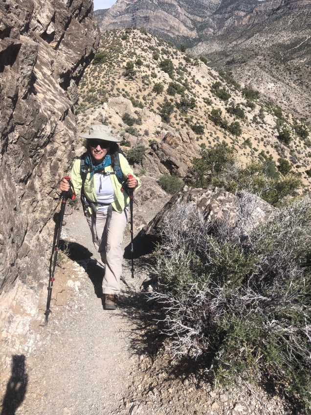
I knew we were in trouble when J convinced me to go up and over a bluff – while I was certain the easier route lay below. After all, the lower route is exactly where the other hikers were. Nonetheless, up and over we went, only to be faced with another even steeper section. J, apparently believing left and up was always the right way, pushed on; I, certain a better way lay below, kept going along my own personal trail.  But after a bit – and seeing J well above me and the ridge towering above that – I realized I needed to get onto some semblance of a trail that would carry me on up.

So, with Ossy’s words (Shifting Winds Lead to Cotopaxi Summit) echoing in my ears, I started thinking to myself – right, left, right – just find your next step – and wend your way up the side.  I found myself on a couple of ledges and unstable spots – but shaky legs and all, eventually wound up next to J, with trail markers in sight. I’m pretty sure that little scramble is the source of the arm bruises.

From there, it was simply a steep slog to the summit.  The foliage changed to small scarred trees (sort of like what I remember from the North Carolina coast).  Once we got to the top, and with the elation that even a 6300 foot peak can bring, I totally lost my concentration and managed to stumble on a relatively flat surface. Bruise #3, the leg bruise.

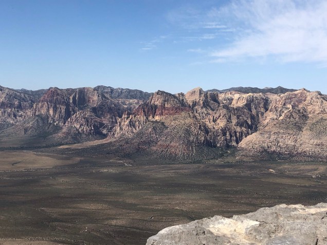
We spent about thirty minutes at the summit, ate our power bars, and took photos of the sculpted peaks surrounding us. A little yoga, of course.

What goes up must come down. Miraculously, we were able to see trail blazes the entire descent – which simply confirmed how far off the trial we (I) was on the way up.  The descent went much faster, but there was the one moment where I realized sitting down and then stepping onto the next rock was the best way down one section – resulting in that unique, not to be replicated – R -I-P – of your hiking pants. I knew it was a risk when I decided on that strategy. Those pants have been with me since Kilimanjaro in 2011, though, so what better way for them to meet their maker.

We hiked back to the parking lot by the sandstone quarry, watching the people who’d decided to try to climb the sandstone cliffs as opposed to hiking on up to Turtlehead Peak. It looked hot and miserable.  In fact, the way down was cooler than the way up, even though it was then close to noon, as the sun had retreated behind the clouds.

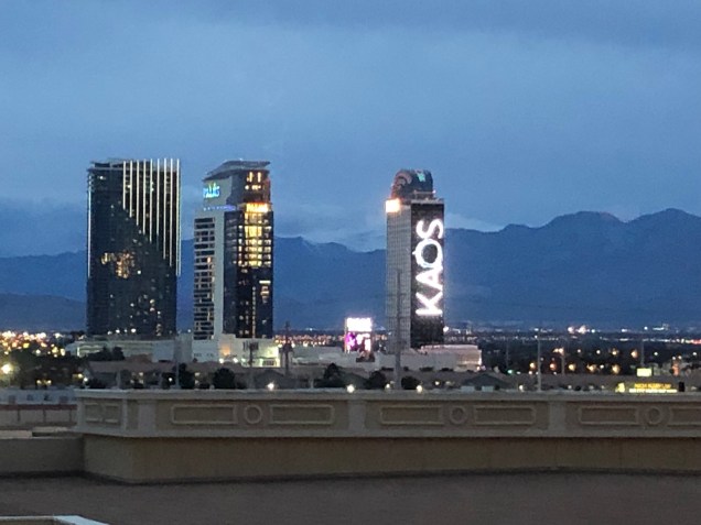
After finishing the 13 mile scenic drive through Red Rock Canyon (you have to, because the loop is one way only), we were back in Las Vegas in 40 minutes.  Back to the land of casinos and cards.  A red eye flight to Florida awaited us.  As well as a wedding of the son of dear friends M and S back in the swamp.


To the Balkans via Red Rock, Nevada

Turtlehead Peak, photo by Bob Wick

Last Sunday I spent a wonderful 35 minutes running up St. Charles and winding around the Irish channel neighborhood of New Orleans.

The Irish Channel

Yes, after almost a year long break I’ve decided I’m back into the running world. Not sure I’m ever going to make it back to seven milers, but it felt wholly liberating to run up one of the most beautiful boulevards in one of my favorite cities in the world.

But I’ve been having a motivation set back. J and I looked up the difficulty level of this summer’s adventure to the Balkans and it was a whopping 5 on a 10 point scale. Everest Base Camp was a 7. Stok Kangri a 9 (and I think that’s an underestimate). Without some sort of “you might die if you don’t train properly” incentive out there it is very difficult for me to put on the backpack and hike those extra flights of stairs in the office building, much less brave a run in the mid 90 degree weather we are already experiencing.

So, what better than to try to combine work trip number 3 to Las Vegas with a hike.

The mountains in the distance call…

I started off by googling “hardest hikes around Las Vegas.” Uniformly, Turtlehead Peak kept showing up in the search results.

It is a high desert hike with 2000 feet of elevation gain in 2 miles. There’s no shade and “bring lots of water” seems to be the main advice. Start early before it is even hotter seems to be another one.

We haven’t hiked in that environment since Sedona, during the year of the Grand Canyon (see Journey through Time -Out of the Grand Canyon and on to Sedona – Part 3 ), so our desert boots may need some shining.

Frankly, from what I’ve read this hike promises to be more difficult than any we are doing in the Balkans (famous last words; I could be totally wrong). Any difficulty will be compounded by the fact we plan to take a red eye back to Orlando that night to make it to a Saturday wedding.

The upcoming combination of heat and dry desert air, extreme steepness, and lack of sleep should be enough to get me out there. We’re going to hike in the Black Bear Wilderness today. Despite the mid 90 degree heat.

Yes, that is an alligator.

The Lost Series – Lost in Las Vegas

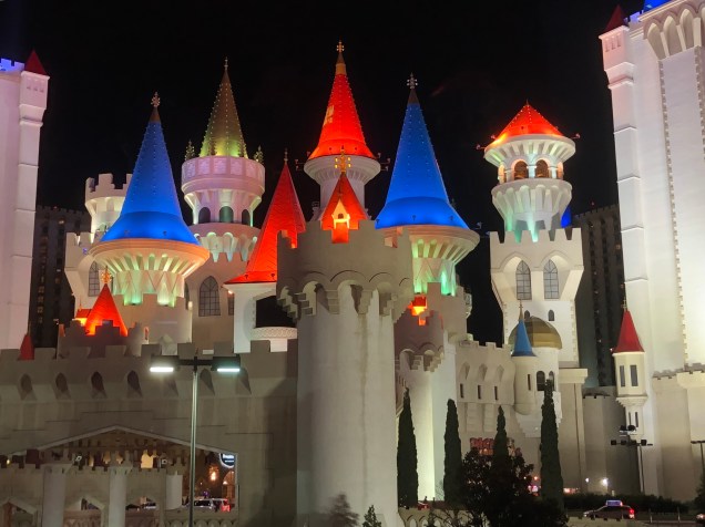
So the experiential content of my life has been increasing recently – along with an accompanying lack of time to memorialize said content. Let me take you back just a few weeks ago On a journey from the swamp to the desert…that is, to the brown sand, concrete neon oasis that is Las Vegas.

Now, what took me there, of course, was work. LV is a place I’ve not intentionally avoided but it just hasn’t ranked prominently on my radar as a place to aspire to go. In fact, when we went to the Grand Canyon way back when we went through Phoenix.

But there I was – my deposition having finished unexpectedly early and with an entire afternoon and early evening ahead of me before a 6 am flight back to the swamp. I was faced with a choice – take an Uber to the Red Rocks park which another Uber driver assured me was the nearby best place to hike (always take the recommendations of your Uber driver) or venture on an urban hike to see what the heck people really do in Las Vegas. I chose the latter.

So, I ubered from the new millennial style Tru by Hilton hotel (with multiple USB outlets for all your devices) to Mandalay Bay, which appeared to be the northern most edge of the “strip.” I realized, as I emerged from the Uber, that I’d forgotten my sunglasses and was absolutely blinded by the brilliant desert light that hovers over Las Vegas. So what can one do but head into the Luxor casino, next to Mandalay, and buy a pair of sunglasses at a what appears to be a 7-11 in the midst of a casino. I was there with multiple people buying wine in cans and airplane size minis of Crown Royal.

Anyway, sunglasses appropriately purchased, my black pants, tennis shoes and green silk blouse on, I ventured forth for my solo girls night out in LV.

I had a client, who many years ago did all the hard scaping for the Bellagio, and a friend who’d told me it was worth seeing – so that was my goal. I made it beyond Egypt, apparently crossed continents and oceans without realizing it, and found myself in New York, with a full skyline ahead of me. Empire State Building, Chrysler – all there. After wandering around for a bit in what looked like a mall food court I got back on the street- and discovered all the retail stores were below ground!

I’m of an age where I just felt I couldn’t go to the Bellagio wearing tennis shoes. So there was a Marshall’s ten feet down that I thought must have a better pair of shoes. Which they did. After a whopping expenditure of $24 (actually I had to talk the cashier down on the price because apparently I’d picked up the seconds) I made my way back up said stairs to surface level where I sat on the curb next to several homeless people and changed shoes. I spent the rest of the evening carting my belongings around in my Marshall’s bag. So on I went – checking out the King Arthur themed hotel – all the way to the Bellagio – surely this side of Eden.

It was actually pretty spectacular. All done up for spring with an amazing combination of fake and real feathers and flowers. I went to the bar in the main level that was featuring happy hour prices and appetizers, figuring I could certainly find food there. The hostess – asked if I’d like to sit at the bar — and said by the way I love your emerald green blouse. So I and my Marshall bag found a nice spot at the bar where I ordered some salad with some very retro name that totally escapes me but there were beets, cheese, and lots of lettuce.

On my left was a guy who drank nothing but was there, as he told the bartender, for the cheap happy hour prices. Bartender said – – are you local? He said yes. Professional. Bartender – Poker? He – yes.

On my right – a woman who’d been to LV many times – whose husband was off gambling while she hung out at the bar and would meet up with him later. From Wisconsin.

So after my scintillating dinner experience it was time to walk back to where I’d seen the Uber pick up spot near the Mandalay. (I didn’t realize there was another mile of the strip I hadn’t even ventured down).

That led to the exploration of the habitrail overpasses through Las Vegas. Loved the casino Aria giving nature aphorisms in the midst of the neon. Got really lost at that overpass. And back to King Arthur’s palace where I just started to photograph people’s shirts.

Awakened in time for my 6 am flight. I go back in three weeks. Think maybe it will be the red rocks hiking trail next time.