An Announcement- Stok Kangri, India

IMG_0069

Stok Kangri is a snow covered mountain 6153 meters, or 20,187 feet, high. Yes, that is a reference to Hemingway’s “Snows of Kilimanjaro” and I don’t expect to see a snow leopard, dead or alive, anywhere up there.  It’s supposed to be pretty arid.  And, it’s only partially snow covered. But Kilimanjaro is what started J and me on this summit journey, seven long years ago. God willing and the creek don’t rise, we’re off to Stok Kangri in the Kashmir region of India starting on June 24 of 2018.

To top it off – it’s not just the two of us, but our friend SB, from Alaska, is going too! I sent a casual Facebook post to him about our tentative plans, and within 72 hours he’d committed. SB is the person who gave me that last push – and I mean a literal push – to get up that last steep incline to the top of Mount Elbrus in the Caucuses region of Russia when I started this blog in 2014. Ever since, J and I have said how much we’d like to climb with him again –  and now we are! He’s climbed Denali and Aconcagua and actually knows what he’s doing. Provides a lot of confidence for J and me.

This is going to be a first. We’ve made it to 19,347 feet on Cotopaxi in Ecuador in 2015. But we’ve never made it to that elusive 6,000 m/20,000 ft. peak. This is our one chance, before we go totally grey and spend our time sitting by the fire – although in Florida that would mean before a cool air conditioner. There will be a lot of more details to come.

The training begins.

Everest Base Camp – M and S Speak! Guest bloggers.

IMG_0142It did all start in 1991. Only one of our now four children had been born. She (A) spent much of her time in a plastic contraption that we called her rocket seat — a plastic rocker with a foam insert and a carrying handle that proved very useful for lugging her around to all the restaurants we still planned to go to with our good friends M and S.  The fact we were 29 and 30 and found ourselves with an infant offspring was not about to deter us.

As the years went by and the offspring expanded to include three others, we four parents found ourselves in high risk environments – such as a fondue restaurant with four under 8 year olds – with hot oil, fire and long sharp forks – and various other and sundry similar problems and situations. They are the subject of another blog post – or possibly even another website.

But throughout it all was always what we used to call our travel fantasies. It could be Vietnam, New Zealand, wherever. Just something more than New Smyrna Beach or – heaven forbid- the Outer Banks. We called it travel p**n – the fulfillment of our travel fantasies – but I’m concerned WordPress and Facebook will block the  phrase of what we actually called it. Just understand – it was supposed to be the ultimate escape and self realization.

Travel po**n kept us going through many a career shift, stressful work situation and the other vagaries of life in the ’90s and ’00s.

After some preliminary trips to see if we really were compatible adventurers – see Iceland Part 2 – The Golden Circle, or All Roads Lead to Fludir, we decided late 20’s angst could translate to mid 50s midlife crises. So we went for it. I’ve already published J’s and my experiences on our trek to Everest Base Camp with friends. Here’s the take from the other bedroom in our amazingly cold tea houses in Nepal and how it happened:

M and S speak:

“You could definitely do it!”

J nodded emphatically as he picked up the conversation thread from MR. As always, J’s contribution focused on the technical specifications. “It’s all trekking. There’s no climbing, so no ropes or crampons.  We go alongside the Khumbu Glacier, not across. Highest we get is only 18,000 feet at Kala Pattar—that’s the best views of Everest.  Kala Pattar is steep and there’s some scree.  But you should be able to make it!

MR chimed in eagerly at each reference, “It’s basically just a really long hike.”  “You’ve got boots and rain gear. You’ll just need to buy some poles.” And “Kala Pattar is an optional day. We could just leave you behind.” [They did.]
E familia.

IMG_0137
“Just leave me behind,” S called out, only half in jest.  He was sitting on a rock, head bent down, one arm stretched in front of him, palm facing out.  It was the universal signal of defeat.  We had updated the wills before we left but our Nepalese guide, Z, wasn’t having anything to do with S dying. “You have to keep moving, S.  It’s not good to sit too long at this altitude.”  I caught up to where S had planted himself.  It wasn’t like I was moving any faster.  Z exhorted both of us with the now familiar, “Tomorrow will be easier.”  Z told us things that weren’t always 100% true.  Like “rest days” were anything but.  Turns out every day was hard and “rest days” (a/k/a acclimatization days) were the hardest!

Since S and I spent most of the time staring at our boot tops, we are grateful for MR’s detailed posts which we can confirm are based on contemporaneous and copious notes.  S and I huddled exhausted around the yak-dung fires in tea houses fighting to stay awake long enough to eat dinner.  MR was on-line busily researching and cite-checking.  It was enough for us to simply say, “We did it!”

“We did it” began long before we were captured, smiling but completely, utterly spent, in the photo taken at Base Camp.

“We did it” began years ago at that very first meal with MR & J talking about how, one day, after the kids were grown, we would go on a “couples vacation.”  Until this year, that continuing conversation had yielded only a few extra pounds, a shared condo in St. Augustine for the Gentlemen of the Road concert, and a long weekend in Iceland functioning as something like cold-weather gear crash dummies for one of MR and J’s upcoming summit attempts.

“We did it” included:  going to a gym to attempt to regain something resembling good shape (and updating the wills just in case); buying a ton more gear than MR and J let on would be required; flying twice as far as we had ever flown; trekking ten times farther than we had ever hiked—and that was twenty years before; sharing close quarters and more about our bodily consumption and elimination than we were comfortable; and worrying that we might end up ruining someone else’s trip of a lifetime by succumbing to altitude sickness or injury.

IMG_0155

IMG_0579

We did it” also included:  being graciously welcomed into the homes and monasteries of people from a rich and vibrant culture; sharing the trail and tea house conversations with travelers from around the world; getting, if not to the top of the world, then pretty close; beating back the demons that taunt us as we age with the bold statement that we’re not dead, yet; discovering that friendship can survive the trek to Everest Base Camp; and, having taken every step together as a couple, finishing the last, longest, hardest day together.   Our marriage is the stronger for it.

MR and J were right.  We could definitely do this!

205

Everest Base Camp Trek – Under the Eaves of the Roof of the World

IMG_0376

It had now been eight days since we left Orlando, and we were finally ready for our trek to Lobuche at 16,180 feet.  This took us well above the tree line into a very barren area, through valleys occupied only by grazing yaks (who seem able to eat anything), and what can only be described as a stone hobbit house for the yak herders. Everest peeked through clouds and mountains in the distance.

IMG_0399

We had lunch at a tea house on the other side of a slightly less scary swinging bridge, which was followed by a very long uphill, culminating in the many memorials placed in honor of those who have died on Everest. They reminded me in some grim way of the above ground tombs you see tthroughout New Orleans.

IMG_0382

From there, it was more up and down and finally into Lobuche. We were by now completely out of village culture and into trekking culture. We kept running into the same people everywhere – the guys from India, the nurses from Florida who were working in Nepal, the Australian couple. And I think I forgot to mention that he who hogged my seat on the flight to Katmandu ended up staying across the hall from me in Dingboche!

The Oxygen Altitude Hotel was our next residence and one of the worst bathroom experiences yet – even though by then we had adapted to the fact that the existence of an ostensibly normal looking toilet meant nothing about flushing. Instead, flushing was correlated to the barrel of water with the plastic jug floating on top that was placed next to the toilet – and usually in just a spot to make it hard to close the door. But when you realize how difficult it was just to get that water there it becomes much more understandable. At that height – despite the surrounding glaciers – there’s no easy water source. There’s also no source for fuel. Yak dung fed the one stove in the dining room – and it was the only source of heat.

After we arrived,  J and I went with our guide for a short acclimatization hike up the nearby ridge to look at the Kumbo Icefall. I forgot my poles and it was dicy on the way up and started to snow on the way down. The Icefall itself looks like someone took a big bag of snow covered ice cubes and dumped them down a slide.

None of us slept well that first night at over 16,000 — and the next day was to be the trek to Gorak Shep and EBC. We started at a reasonable hour but the team wasn’t moving very fast – it’s a lot harder to get oxygen at that altitude – and we ended up going first to Gorak Shep, checked into our tea house and had lunch. This was a much smaller lodging – our rooms were up three flights of completely uneven stairs – some almost 20 inches high – and I found getting to the room as hard as the trek itself. To add insult to injury, due to the water issues the inside bathrooms were barricaded off during the day!

The trek to EBC – theoretically the talisman of the trip – is challenging. You hike alongside the glacier – mostly stone-covered but with deep divots through which you can see tens of feet of blue ice and frozen lakes.  Lots of rocks to pick your way between and finally you reach what feels like a natural levee between two valleys that you hike along.


IMG_0410The creepiest part of the experience was to hear avalanches and rock fall by Everest and the surrounding g mountains. J and I were hiking by ourselves ahead of the team. At first I heard a sound like thunder – a slow roar, a rush, and then I heard someone yell from across the valley. I think it was on Lhotse. We heard several more similar soundtracks – and on the way back I saw a huge rock become dislodged and start a slide.

We waited for M and S at the levee just before base camp so we enter together surrounded by prayer flags. It’s very spread out and I wish we’d had the time to poke about. Weather had been terrible at the summit so most of the climbers were still at base camp.

IMG_0424

After photos, we headed straight back. Exhausted and early to bed – especially since J and I were rising early to climb Kala Pattar – 18’200 feet – which was our main mission.

We got up at 5, had a coffee and a Cliff bar, and met up with our guide. Our tea house was very close to the beginning of the trail. Very steep dirt for the first part and my fingers were absolutely numb. The ground was frozen solid. Then, there was sort of a tundra area and another steep uphill, this time through black stone (which is what kala pattar means). A tiny bit of scrambling, especially at the top – and we were there. Surrounded by the panaramic view of the highest of the Himalayas – I finally I had that over 18,000 feet of altitude nothing will get to you feeling that happens only  at serious height and after days of trekking. I was happy.

Descended, and had breakfast with M and S. We headed back to Lobuche, for lunch at the Oxygen Altitude. We were about to start the trek for the long way home. (More to come in that front.)

M and S had never done anything like this before. They did great. But it’s nothing to do with the training or  physical discomfort you endure. The outcome of trekking at high altitude takes a while to sink in.  The reality is – no one and nothing can ever take away it away from you. We had stood in the attic just under the roof of the world.

Everest Base Camp Trek – Tengboche and Dingboche (or Lost Horizons)

IMG_0293

After two nights acclimatizing in Namche Bazaar, it was time for the march to continue. Sleep patterns were by now most peculiar – I found myself asleep by 9 pm, awakening at 1 am or so and reading, and then returning to sleep. I seemed to have reverted to the Middle Ages concept of first and second sleep.

The day we left Namche was the day before Buddha’s Day. We walked clockwise (of course) around the monastery where prayers had already started and along the trail that we had looked down upon the day before. At first it was relatively flat, with some gradual ups and downs. After some time, we entered the Sagamurtha National Park and the altitude where the rhododendrons were still in bloom. Pink, white, red – forming an arcade over the trail. Another swinging bridge – I can feel myself start to sweat – and then time for lunch in a small cafe. The walls were covered in tapestry and all the food was prepared by two women over a wood burning stove. It felt as though we were in an old fashioned gypsy caravan.  After, we were backed against a wall by one of the many yak trains coming through. This was S’s first of many encounters of the not good sort with a yak.

IMG_0291

A couple of hours of up through layered jagged mountains, overhanging fog, framed by rhododendrons.  These mountains are new, geologically speaking, and a young world appeared around each bend in the trail.  Light green trees interspersed with dark pines, creating a textures that clothed the mountains.  We made it to the top in a respectable time, turned a corner, and suddenly we were at the Tengboche Monastery.

Checked in to the Tashi Delek Lodge and then visited the monastery. Tengboche is centered around the very old monastery – there were a few tea houses for trekkers and a bakery, but we were now far away from the village culture we had previously experienced. It is bucolic. There’s an open meadow area where cows roam, the gate to the monastery and some low buildings where the monks live in numbered rooms, and a few grey stone tea houses.

IMG_0310

Six of the 12 resident monks sat in the center, chanting in a low drone. They spend their lives here, in very small rooms.  When we stayed at Tengboche on the return, we saw the younger ones going off to play soccer, crimson robes flapping in the wind.

The fog rolled in, slowly covering the small dwellings.

The next day we trekked to Dingboche, where we were to spend two more days acclimatizing to to over 14,000 feet. We could hear prayers chanted in each of the villages as we walked through.  The wooded part of the trail soon opened up into a stony valley – the milky river below and some serious rock slides where I did not want to linger. Ultimately we ended up in Upper Pangboche. Most trekkers go through Lower Pangboche only, but it was clear that our guide wanted to make a special stop at the monastery for Buddha’s Day. This is a 400 year old structure, founded by a monk who allegedly flew there. Various people were coming in and out to pray for Buddha’s Day. Z lit a butter lamp, incense was burned, and he prostrated himself three times. A lay monk poured water in all of our cupped hands to drink and smoothe on our foreheads as an act of purification. He also showed us a niche in the wall of the monastery that housed a relic of the flying monk – a bone of some sort.

IMG_0328

Hiked on and on, including a stop for lunch, and then another couple of hours to Dingboche. Trail normally about 2 feet wide, sometimes with very steep drops on each side. Across the river the stones were white with splashes of red. We were above the tree line now. Small junipers, yaks, and a lot of helicopters making their way to base camp.

in Dingboche we stayed at the Good Luck lodge. It was packed. We had a nice little room where the sun shone through the window and it was almost warm. The last few have been cold and damp. We are now at the point where yak dung provided the only fuel for the fire in the comunal dining area (which is never ignited before 5 pm). The middle of Dingboche is all privately owned potato fields – to get anywhere you have to walk three sides of a square.

The next day we did an acclimatization hike to the Chukung Valley. We followed the milky river. A wide, stony expanse, with Ama Dablam peering at us from the right, Lhotse to our left, and Island Peak in solitary splendor straight ahead. We stopped at a cafe – and who was there but the guy from the plane. This time he explained that his seat hogging actions had been fueled by a few too many pints after he unexpectedly ran into a cousin at the Dubai airport. He and his friends were doing the three pass EBC route.

IMG_0344

There was a piercing wind on the way back and we went much faster.  Once safely ensconced in Dingboche,  J and I explored the village while M Andy S made friends with some fellow trekkers who were happy to share the very exotic salami they had brought from France. A nice change from gu’s! The dining room was packed because the rooms were so cold.

We were now acclimatized to over 14,000 feet. Next up – two nights at over 16,000 feet – EBC itself and Kala Pattar!

Everest Base Camp Trek – Lukla to Namche Bazaar (or the Bridges of Doom)

ALERT – photos will have to be uploaded later. I’m writing from Nepal – and am seriously wifi challenged at the moment!

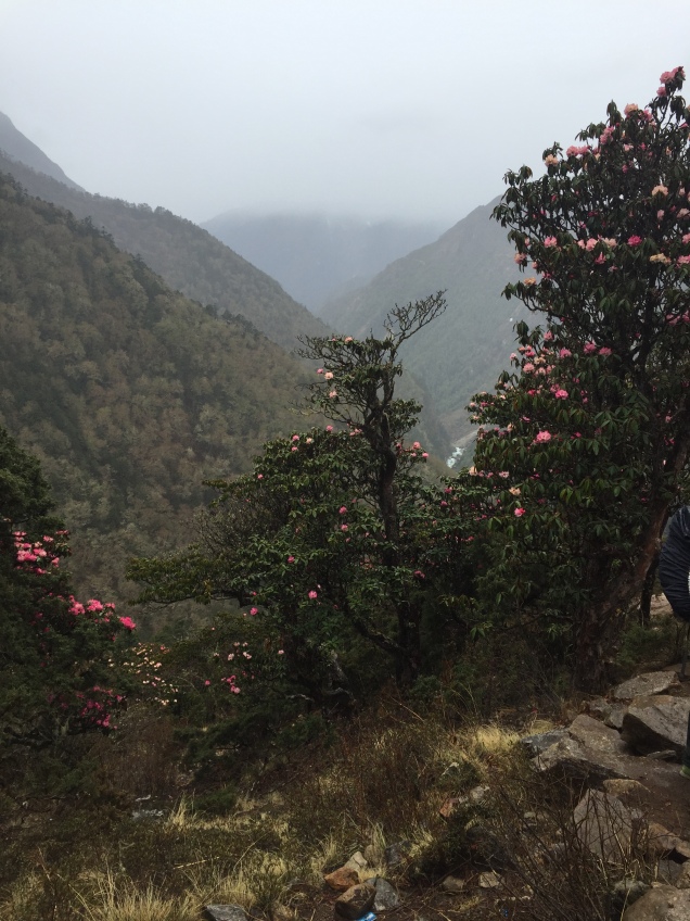
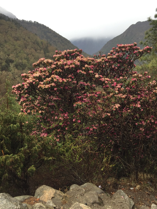
After we exited our flying tin can (also known as a Twin Otter) in Lukla and had a cup of tea, we immediately started uphill. The first part of the EBC trek is nothing as much as a human highway connecting numerous small villages. There are no combustion vehicles of any types – no farm equipment, no cars, no trucks – and correspondingly, no roads. Instead there are yaks, gakyos (1/2 cow and 1/2 yak), and humans. Regardless of their size, they are all carrying huge packs. Yaks were carrying sacks of rice and blue containers of kerosene; one very small gentleman was carrying a load of rebar and another a full size freezer. Apparently the humans are paid by the amount of weight they are carrying. I have never seen such strong people – including at  any gym I’ve ever been to.
Each little village has at least a mani stone – a large rock painted with mantras, frequently om mani padme hum. (I read a translation today at the Sherpa Cultural Center that said it meant “hail to the jewel of the lotus,” but I’m not sure how much stock to put in that.) You pass to the left of the stone, always clockwise. Many villages have prayer wheels, ornate cylinders also engraved with prayers that you run your hand along, turning them always clockwise. Some prayer wheels are powered by water. Sometimes bells ring as they turn.
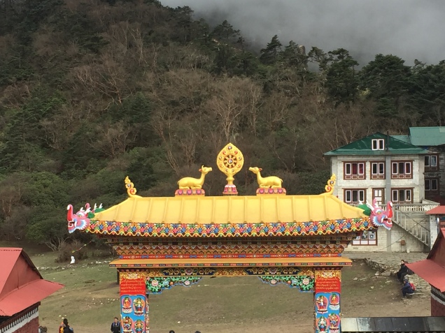
A lot of places welcome you with a stupa. From the air it appears as a mandala. Generally, three terraces at the bottom represent the foundation of meditation. The dome is the womb of emptiness from which all comes. The box on top is painted with the eyes of the guardian Buddha. Some stupas, instead, have a statue of the Buddha in a glass enclosed niche. The 13 steps above represent the 10 levels of compassion and the 3 levels of tantric awareness. The umbrella is the sovereign sanctity of the Buddha mind and the crowning jewel in the top its wish fulfilling capacity. Buddhism is woven in to the fabric of everyday life here. On the return part of our trek I saw an old man sitting outside his tea house, running his fingers along his mala (a rosary of 108 beads) while spinning a handheld prayer wheel. His wife sat next to him, wearing the traditional long skirt with a woven apron on top, while their dog slept in the sun – all with the majestic mountains towering in the background.

Most fantastic – that first day at least – was Gauri Ghat monastery. An elaborate structure in the middle of the area, multiple prayer wheels under shelters decorated with paintings of the Buddha. A feeling of serenity throughout.

I had known before this trip that at some point I would encounter my nemesis – the swinging bridge of doom. It happened shortly after we left Lukla. For years my most frequent anxiety dream has involved a swinging bridge over a gorge where I can’t move forward or back. And that is exactly what I had to cross – following M’s white hiking shirt, feeling the bridge sway – at least 100 feet over the rapidly running river. I refused to look down or to the side (where I could tell the chain link fencing that formed the sides had been kicked out at the bottom, leaving a realistic possibility of slipping through). Saying mantras was a necessity.

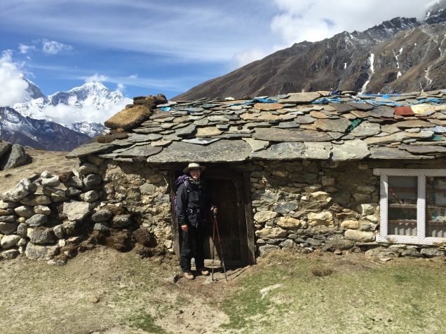
After three hours we reached Phak Ding and our first experience of tea house culture. The tea houses changed as we worked our way up to EBC and away from village into trekker culture. More on that later. But typically there’s a dining room that serves as a communal living area, common toilets (although our first two tea houses had “en suite” toilets – little did we know what a luxury that was!), and very cold small plywood pine rooms with twin beds, sheet and blanket, and if you were lucky, hooks and a light that would work after 6 pm. Ultimately we realized we needed to regard the rooms as a sophisticated version of a tent.

After lunch, we took a steep acclimatization hike through a pine forest and small fields of potatoes and onions and spinach to a monastery that was being repaired. The monks were painting elaborate designs in geometric and representational patterns in colors for each of the five elements (iron being the one I didn’t know about). The paint contained a special resin to make it shine.

We had to cross a second swinging bridge to get there – which made me no happier than the first – when who should appear but the guy who’d sat (slept) next to me on the plane. We recognized each other and exchanged pleasantries. Given my bitterness over the seat hogging, this was a fitting karma experience to accompany all the monasteries we had seen. And it’s not over yet.

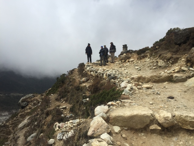
The next day we trekked to Namche Bazaar (originally Nauche) where we were to spend two nights. Much of the route was along the Milky River, a mint green blue rapidly running river that accompanied us most of the way to EBC. Today involved not two but five swinging bridges. Fortunately M continued to wear the white hiking shirt so I still had my driste to focus on. We had a lovely lunch by the river and the trail got progressively steeper. Fabulous views of the Three Sisters along the way. A yak herder following his yaks, while carrying his dog down the mountain.

We reached NB suddenly. A pretty village of square stone buildings with a interesting mixture of trekker culture and village life. Trekking has been part of Nepalese life since the 1950s. What’s amazing is that every last thing has been carried here – by human or animal. Namche does have a small airstrip for cargo, but even then – everything has to be moved several miles to the village.

A very nice tea house with some beautiful woodwork in the dining room but COLD rooms. There was even a version of a shower with hot water (the last one we would see for days). Probably the prettiest tea house we stayed in. Unlike the very crowded places further along the route, we were the only people staying there.

After we arrived, we went to the nearby monastery. A stupa is being rebuilt and the monks, all in crimson robes, were conducting four days of prayers to bless the items that will be placed in the stupa. Plus, day 4 is Buddha’s Day and there will be a big celebration. Because 12 monks were needed the prayers were occurring in the common area instead of the actual monastery itself. All of them sat in a row; the leader chanted in a deep sonorous voice and the others chimed in with various instruments- symbols, something that looked like a clarinet and bells. At one point plates of food were brought out as offerings – they would ultimately be left for the animals. There was a huge gold Buddha on one wall and a monk folding prayer shawls.

We visited the upstairs museum, near the rooms in the upper galleries where the religious objects are taken care of. A monk asked us if we wanted to go to the actual monastery where the prayers normally occur. 300 years old, the walls were painted with images of Buddha. There was a shrine with statues of the past, present and future Buddha. Butter lamps lit, colors and patterns on every square inch, but a sense of peace emanating from the sensory overload.
For dinner S and I tried yak curry, although I think it is usually buffalo. More of the local spinach, rice, potatoes, dal and apple pie for dessert (which was almost like an apple baklava).

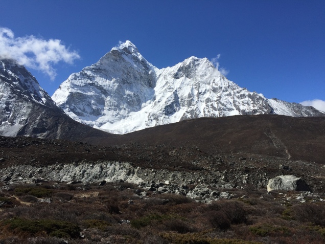
During our full day in NB, our acclimatization hike to the viewpoint at the Everest View Hotel allowed us our first view of Everest, Ama Dablam and Lhotse. We trekked gradually at first and then steeply up to about 12,600 feet, from pines to scrubby pines. Then down the other side of the valley to Kung Jung (sp) – tranquil, uncrowned, green rooves, and the home of the school founded by Sir Edmund Hillary.

After poking around NB in the afternoon, we had Sherpa Stew for dinner. A thick broth with dumplings and potatoes, ginger, spinach and carrots.

Next move – to Tengboche and Dingboche.

I’m busy. I leave tomorrow. Everest.

No photo in tbis blog. I’ve been too busy. I started this post with five days to go. And now I’m staying in the hotel at the airport in preparation for a 6 am flight, followed by 24 hours plus of traveling.

I’ve faced my usual paranoia that the ridiculous hours I’ve been working in order to garner 2 1/2 weeks off will have so impeded my training I’ll find myself coughing as soon as I hit 10,000 feet, only to have a so far unexperienced asthma attack, get pulmonary edema, and expire somewhere at an unimpressive 12,000 feet. Matters have not been helped by the death of Ueli Steck a few days ago on Everest.

One can’t help but wonder about the possibilities. But more important than the possibilities – however tantalizing they may be – at least for those of us who have some great need for adrenaline – is figuring out why you’re going up the damn mountain  in the first place.

The busyness – business of our lives has taken over. I don’t know about you, but if one more person asks me to do one more thing, I might just combust. I’m called upon every hour multiple times per hour to make decisions. Some small; some large. Whether my recommendation affects one or thousands – you know what? It’s just as important if it affects one person’s working life as it is if it affects many.  Jobs are important to people.

Back to topic. I’ve been training for this trek since we came down from the last. And I really, really need to get away from that busyness – business. I’m hoping that somewhere in Nepal, on the way to Everest, there’s some fabulous lost horizon that’s going to give that sense of peace.

Namaste.

Trekking – Bridges Cross Gaps

img_0059
On the way to base camp – photo by James Hellman

I’ve been thinking about bridges a lot lately. Perhaps partly because I am living by a ten year construction project called the Ultimate I4.  So far it has manifested itself as a series of disconnected bridges to nowhere. There’s nothing quite as majestic as running under an overpass, only to be met on the other side by a 1000 foot strip of raised concrete floating on mid air like some sort of giant teeter totter.

But I’m also thinking of bridges because I’ve been looking at photos of the trek to Everest Base Camp and have suddenly realized there are a heckuva lot of suspension foot bridges that cross extremely high ravines. I think I read somewhere that there are 27.  Now, when I was much younger (and to be truthful, up to the present day) I used to have a recurrent anxiety dream that involved being stuck on a swinging bridge over a deep gully, absolutely frozen and unable to move either forward or back.

img_0060
Grandfather Mountain swinging bridge – even scarier in the 1970s

I’m sure this goes back to the kernel of a true childhood memory (funny how “truth” becomes relative when you’re talking decades ago) when my family went to Grandfather Mountain in North Carolina.  While I frequently recalled crossing the swinging bridge – from which you could quite definitely have slid through the side chains that were all that separated you from doom – I never admitted to anyone that I was absolutely terrified, right down to the white cotton ankle socks that I’m sure I had been made to wear.

Mountain climbing – or at least aspects of it – is like that. Regular readers may remember a post from a few years ago about training to climb Mt. Elbrus by scrambling  around on my roof. ( Training Up on the Roof ) We did have leaves to remove from the gutters but I also thought it might help conquer a fear of heights.

I guess bridges will be have to be my next such training location. Making myself go forward one step at a time without freezing in place – that’s something to which we can all aspire.  And these days, it’s a lot better to cross a bridge than to build a wall.

img_5488
January 21, 2017 – Artwork by A

Seeing the Summit – Getting Ready for Everest Base Camp

img_5377

I’m not sure I’ve formally announced the next choice of mountain…but the winner is – Trek to Everest Base Camp! Now I realize for you purists out there it’s technically only a trek up part of a mountain, but for those of us who took up mountaineering in our 50s it’s probably as close as we’re going to get to that particular summit. And there are a few peaks along the way, so surely that counts. Much more to come on this latest adventure in the coming months.
But the title of this post is Seeing the Summit and that has particular meaning at the moment. For – for the first time since the reading eye following my lasik for monovision in the early 2000s stopped reading – I can see without glasses!

The secret – a little thing called contacts. I haven’t worn them since the late 90s, but suddenly the glasses were just too much and too heavy. You need a light touch for summits and the glasses weren’t doing it.

It’s quite disconcerting to see your face close up without glasses for the first time in years. I definitely have more wrinkles and grey hairs than I realized. But the ability to read something whenever I look down (ok- I still can’t read the directions on cleaning products) – is amazing.

There’s got to be some clarity in that. And as I resume the type of training regime I think I’m going to need to reach the highest overlook of Everest – Kala Pattur- at almost 18,500 feet –  and to spend about 10 days at over 12,000 plus feet…some clarity is sorely needed.

You can see a lot looking down from a summit – but getting ready to look at one up can be equally as important.

Election Year – Hurricanes, Presidentials and Mt. Jefferson

img_5087
This wasn’t the summit but it looked just about the same!

For the last several years, we’ve spent that most politically incorrect of all holidays, Columbus Day, either in New Hampshire or Maine, together with Boston and New Bedford residents Daughter A and Boyfriend N.

And despite hurricane force winds in Florida, courtesy of Hurricane Matthew,  this year was no different.  Of course, we had planned for a Friday departure, but after even my office announced it would close for both Thursday and Friday, I was pretty sure that wasn’t going to happen.  But it still took our So Budget It Shall Remain Unnamed airline until 4 am Friday to cancel the flight. For some unknown reason I’d woken up almost at the precise moment of flight cancellation and hence was able to have rebooked us before 5 – after which I immediately went back to sleep, lulled by the 60 mph wind gusts.

Saturday we woke bright and early to inspect the debris in the yard. The wind had howled most of the night, but Matthew’s 20 mile jog to the east had made all the difference. We made it to the airport, our one checked suitcase within one pound of an excess weight charge.  All was going as smoothly as it could for a 24 hour delayed flight, until we learned that our Unnamed Budget airline had apparently forgotten to tell the first officer he was supposed to be on that flight. After about an hour, said Unnamed Budget airline snagged two pilots who had just arrived from Texas and who agreed to rearrange their schedules to fly us to Boston.

We finally arrived in Boston about 7 pm. After dinner at a nearby Peruvian restaurant (with Pisco Sours!), N drove us through the night in the old faithful Previa to Jackson, New Hampshire.

We had left our reservations late and knew we weren’t staying at a quaint New England B&B. Instead we were booked at an old style motel, run by a crusty elderly man who had clearly been asleep when we had to ring the service phone after we arrived at midnight. I must admit to a brief moment of panic when I saw all the lights off in the office and the no vacancy signs at every establishment in town.

But we managed to get ourselves checked in and even to wake up  by 7 or so. Well, 7:30.  Our original plan had been to climb Mt. Jefferson and then go over the ridge to summit Mt. Adams. But given the late start and the overall hassles of the last few days, even we recognized that perhaps that was overly ambitious.

We gave A the choice between a shorter and steeper climb or a longer and more gradual one.  Ever the pragmatist, she went without hesitation for the shorter one – Caps Ridge.

It was about an hour drive to the trailhead, which was quite well hidden down a dirt logging road. It was a relief when we finally found the small parking lot and saw other hikers getting ready to start.

img_5099

The trail starts with a fairly steep climb through thick woods. It was overcast and grey and proceeded to get more overcast and grey the higher we climbed.  After a bit, the trees turned into skinny short birches, their white trunks looking vaguely unclothed with ribbons of grey bark hanging off them.

From the birches we climbed through scrubby pines and finally above the tree line. At that point, the bit we hadn’t been expecting – some real scrambling and rock climbing – suddenly appeared. Frankly, I thought it was harder than Mt. Washington up the Tuckerman Ravine Trail – although it certainly was shorter.  There were at least three sections where we were looking for cracks to scale and I made good use of the shrubs growing on the sides as handholds. A had neglected to bring any gloves and J ended up doing it all bare handed.

img_5118

Toward the top there was a section of big boulders, covered in lichen, where you balanced along the edges of one rock holding on to the one above. It was like some crazy jungle gym that you had always wanted to try in kindergarten.

By that point it was all slippery and even greyer and A was showing tremendous resistance to the idea that a summit was really necessary, wisely reminding us all that what goes up must come down. But at that point, striding out of the mist, came a European climber who looked as though he’d just left the Matterhorn. According to him, the summit was only “10 or 15 minutes” away.  Despite the fact we were now experiencing sharp dry pellets of hail, that gave us the encouragement we needed for that final push up.

Of course, it took us 30 minutes, and the view from the top was as grey as the view from the bottom — but it was still the summit!

img_5101
Summit!

We had made a commitment not to waste time at the top because we had all those sections of rock to slide down. And slide we did. My favorite part was when I saw a foothold several feet below my legs, and figured if I just started the slide I could grab on to a nearby branch halfway down to break my fall. Not very elegant, but it worked.

I ended up climbing a good portion of the way down solo. As I’m usually the slowest going up, I feel I must make up for it on the way down. I had a good head start and it seemed a mistake to intentionally reduce my pace. But voices don’t carry well in the mountains; I couldn’t hear my fellow hikers; and I spent a fair amount of time worrying I had drifted on to a rabbit trail or a dry stream bed and would plow further into the wilderness, never to be heard from again.  And, I was without a phone since J had forgotten his and was holding mine to take photos.  Big  note to self. One group should not have all the phones!

Regardless, it was back through the scrub, the birches and the woods, and I was sitting on a log waiting for the other side when they reappeared not too long thereafter.

We were all absolutely filthy and wet. Back to our little motel, showers, and out for a short walk and dinner. The weather cleared and the brilliant fall foliage that we’d been hoping to see all day was finally reflected in the orange pink sunset.

And how better to conclude our climb in The Presidentials than by watching the presidential debate. Jeffersonian it was not.

Orlando, June 12, 2016 – Swamps and Summits

image

It’s a thinly veiled secret on From Swamp to Summit that I’m from Orlando. That Central Florida city where one looks in vain for a hill to train on and ends up resorting to staircases. Staircases have been good to me. I’ve made it up Kilimanjaro, Mt. Elbrus, Illiniza Norte and Cotopaxi. And more to come. I hope.

I may not have grown up here, but Orlando and Florida reach out to you with their sticky sweaty humid hands and hold you close to their hearts. I moved here in the middle of 1989. Sight unseen.  True story.  It was a snowy night in New York and husband J, who was finishing his Ph.D.  at NYU received a tenure track offer at a small liberal arts college here. I’d never even been to Florida on spring break but after J interviewed in Orlando and described the smell of orange blossom, I was sold.

So after a brief diversion through Greece and Turkey (another blog post in and of itself) we found ourselves, our one room of furniture, and our cat Chelsea in this city we’ve called home for over 25 years.

A swamp does describe life in Orlando this week.  But not the life giving jungle green of the Everglades wetlands.  More the  brown slough of  despond. Exactly one week ago I awakened early, despite having been out in downtown Orlando the night before at a concert. And across my phone came word that at least 20 had been killed at the Pulse nightclub, not far from where we had been and a few blocks from my office. By mid morning the number had increased to 50. 49 victims and the gunman.

This massacre was framed by the Friday night shooting of a singer from the Voice, followed by the suicide of the killer, and the tragedy a day after the Pulse shootings of the drowning of a two year old by an alligator at a theme park lagoon.

The City Beautiful, as Orlando likes to call itself, didn’t look so beautiful anymore. On Monday evening I found myself at one of many vigils around the city at a makeshift memorial that has sprung up in front of the Performing Arts Center. There’s not enough public space in Orlando and what has happened there shows why people need to have a place to come together. There are candles, ribbons, photos, posters, notes written on paper chains. People standing are reverent. Nearly everyone I know has made a trip there.

On Thursday, President Obama and Vice President Biden arrived. I watched the motorcade from my office window, together with some of my partners. I’ve seen many grown men cry in the last few days.

image

That night, J and I went back to the memorial. A motorcycle club had its bikes lined up, illuminated in rainbow colors. They revved their engines, and a speaker for the club stepped forward and asked the several hundred assembled there to hold hands and observe a moment of silence. Everyone did.

Rainbow flags are flying all over the city and practically every public building has been illuminated in the now familiar red, yellow, orange and blue colors. Tonight is a city wide commemoration that is supposed to be non religious, non political, and non branded. Just a time for people to be together. We’re going to walk down there.

Perhaps after today, and the symbolism of one week later, healing will start.

It’s a long way up any mountain. And it’s going to take Orlando a while to slog up this one. But I know that Orlando and its people have what it takes.

image