Iceland Part 2 – The Golden Circle, or All Roads Lead to Fludir

image

When last we left our intrepid travelers they had just finished slipping and sliding across a parking lot in Reykjavik, tattered map in hand, hail and wind gusts abounding. But day 2 they woke up bright and early to another Scandinavian/English breakfast to boldly embark on the next part of the great Nordic challenge, also known as the Golden Circle. It has a certain Wagnerian overtone – Ring series and all that.

Speaker of the Law
Speaker of the Law

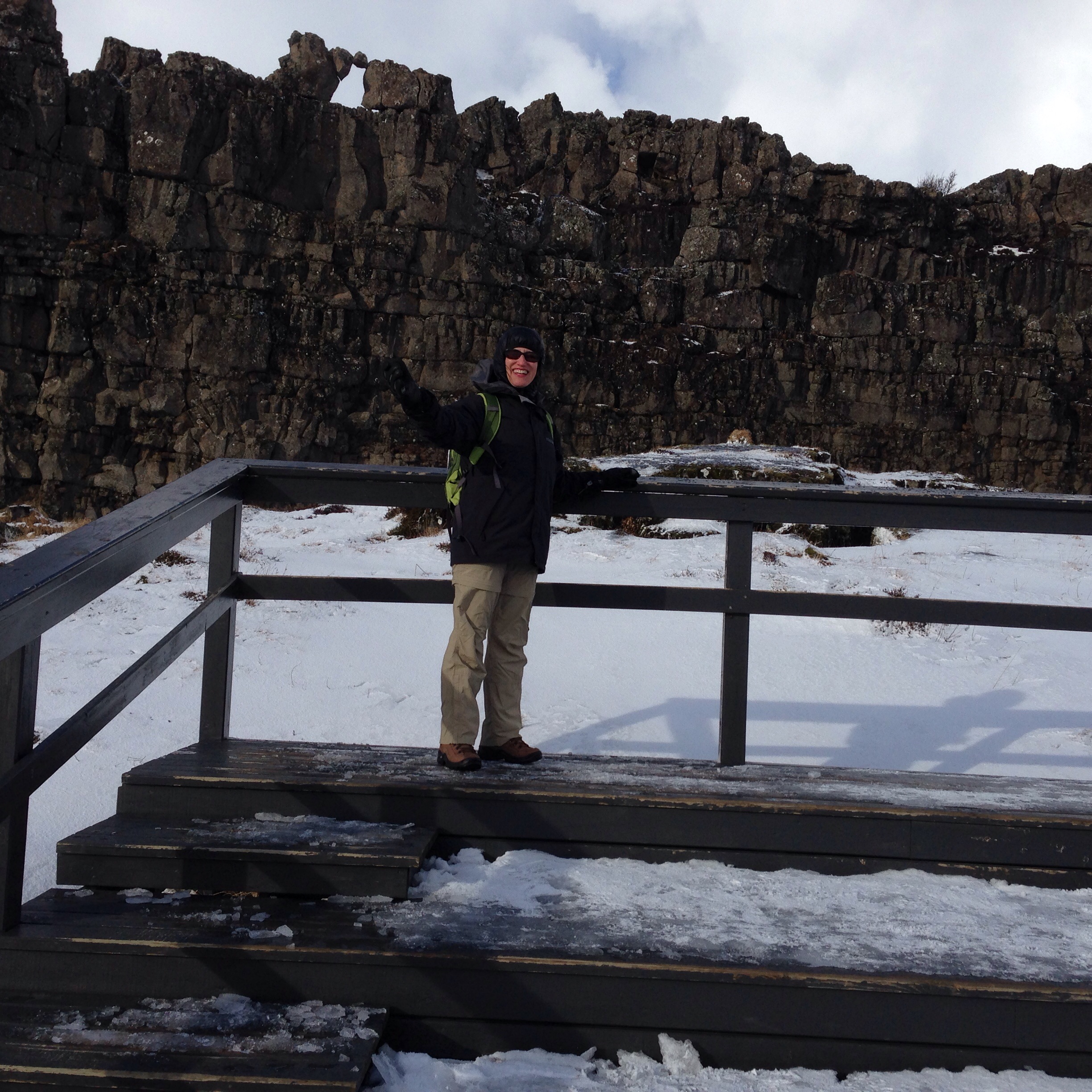
The Golden Circle has three main stops.  First is  Pingvellir or Thingvellir (I don’t have Icelandic characters on my keyboard),  the seat of Iceland’s Parliament starting in the 900s and, according to the signs, the oldest Parliament in the world. Unbeknownst to the ancients they had picked a valley located on the exact rift between the Euroasian and North American tectonic plates, which are pulling apart at the rate of a tenth of an inch a year – in geologic terms, the equivalent of a Daytona 500. You hike down the valley past such illustrious spots as the Drowning Pool and, my personal favorite, the Speaker of the Law Rock. Now if they would just put one of those in a courtroom….

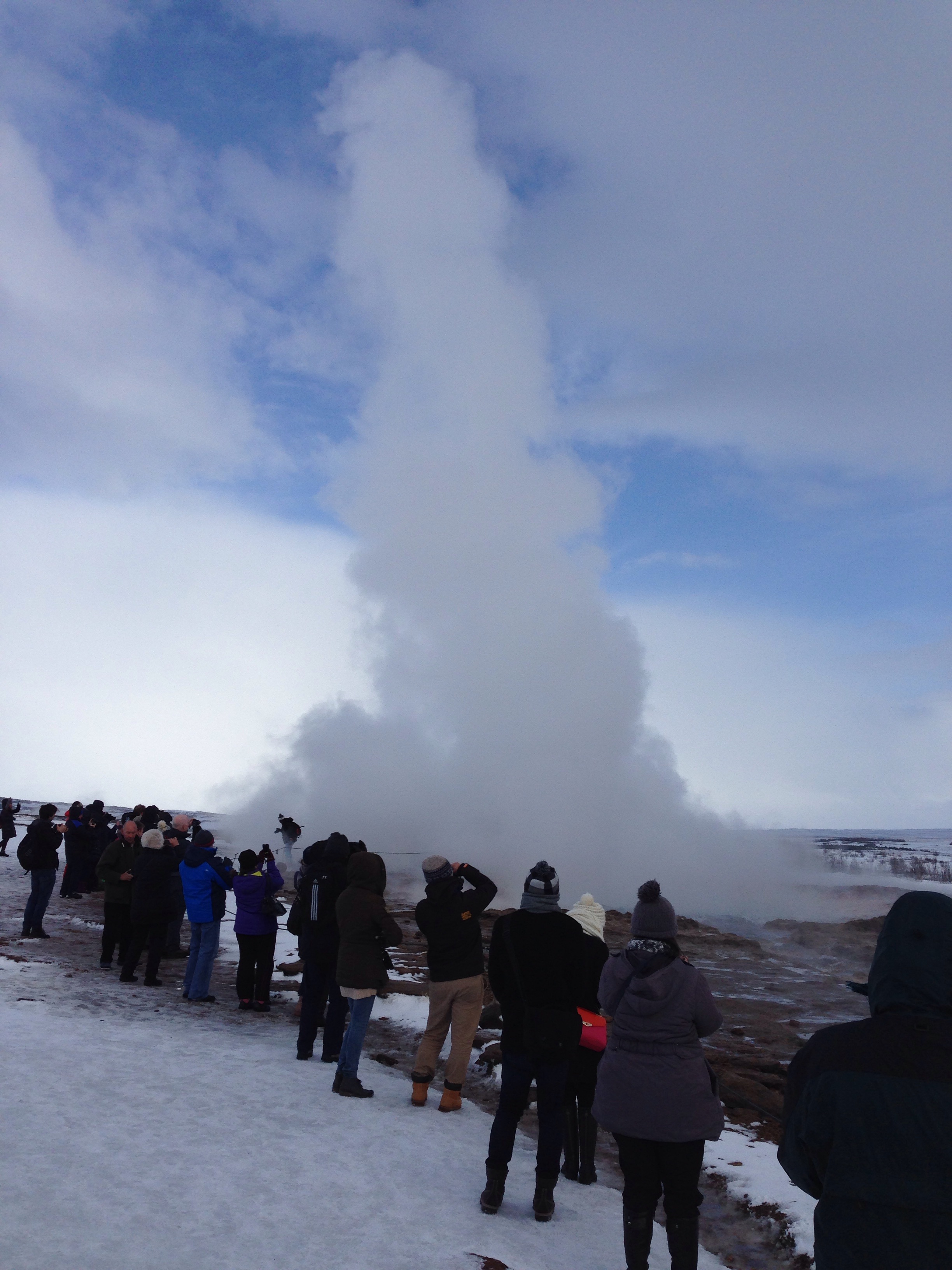
After exploring the seat of ancient Icelandic government, the next stop was the geyser, Strokkur. Unlike its larger cousin, the Geysir, it erupts every few minutes, so no one leaves disappointed. It wasn’t too crowded in early March, but must be a nightmare in high season. Mind you, through all this, husband J was bringing his Florida driving skills to bear through wind and rain and ice and snow. What friends M and S didn’t know until the last day was that he’d waived the collision damage insurance. Strokkur was dutifully impressive, shooting its 20 meter high spout with the regularity of a factory whistle. I personally found the little steam spouts percolating out of the side gullies and small bubbling puddles just as interesting.

image

Continuing our tour – along with a few hundred people doing the exact same route – in fact, I started to recognize people from stop to stop – we journeyed onto the famous waterfall of Gulfoss. After encountering some quite bad weather on the way there, we didn’t even realize we’d arrived. You’re on a high plain, seemingly with no topography, and then an elaborate visitors center appears out of the middle of nowhere. We actually sent S out on a reconnaissance mission before we all ventured out to confirm there really was a waterfall in sight. It is an amazing confection of spray and rock and mist. Not quite as massive as Niagara Falls, it has two tiers and at that time of year, one side is frozen into sharp stilettos, contrasted with frozen rolls of ice that cascade down the side of the valley.  The falls then flow around a bend and plunge into a narrow ravine that must be enormously deep.

image

Aside from the falls themselves, Gulfoss has quite a remarkable gift shop. We had to convince S that he truly didn’t need to take a seal skin back to the United States. Ethical issues aside, the guide books are full of warnings of the dire consequences such attempts will result in at U.S. Customs.  Of course, it is quite likely said seal skin really was produced in some quaint Icelandic greenhouse specializing in man made fur. More on the greenhouses later.

But by then it was mid afternoon, and we felt it wise to get somewhere within striking distance of the Farmhotel where we were to spend the next two nights. As three of us are lawyers (well, M has relinquished the profession in favor of a more divine calling), we followed the “detailed itinerary” provided to the tee, arriving in the bustling metropolis of Fludir in late afternoon – but only after driving through a pounding snow storm on what became our new best friend of a road, I think numbered 341. Little did we know that Fludir would become our navigational tool for the remainder of our stay in the Iceland countryside.

On the way to Fludir

As a point of interest, Fludir has a population of 394. It is located in the unpronounceable municipality of Hrunamannahreppur in the Southern Region, Iceland.  And the way we navigated, we ended up going toward, through and around Fludir for the next couple of days, since all roads seemed to lead to it.

After quickly passing all of its few commercial establishments – including yet another of the  ubiquitous Icelandair hotels, S finally broke down and went into the Fludir equivalent of a convenience store to ask where the Efstidalur Farmhotel was located. It was at that precise moment that J and I both had the same realization. We had noticed some weeks before that the hotel we were booked at was not the hotel featured on the self drive tour company’s website, but was actually located in an even more remote spot, further east and away from Reykjavik. Oh. And the itinerary from the tour company, of course, presumed we were staying at the hotel people were normally booked at. Oh.

So, J and I were not overwhelmingly surprised when S tromped out to announce that the hotel was not here but there and we had another half hour of fun driving in the snow before arrival. But the convenience store lady had given him a very detailed map which became our Bible for the next couple of days.

Through more snow and sleet we went, eventually driving up a steep hill to an actual dairy farm. Cows all around, out buildings, and a small low building of ten rooms, five of which overlooked the wide white valley of fields below.

We were home for the night.

Main building at the Efstidalur Farmhotel


Iceland Part 1 – A Day in Reykjavik

An unusual combination of destinations

Husband J, friends M and S, and I arrived at Sanford-Orlando International Airport on a Tuesday afternoon still not quite believing that one could board a plane there and step off in Reykjavik, Iceland. Yet that’s exactly what happened. After a fairly smooth flight on budget airline Icelandair we arrived in Reykjavik just after 6 am.

For some reason both sunrise and sunsets are late this time of year in Iceland, so we made our way in near total darkness to the Icelandair Hotel Natura. Icelandair seems to be as much a hotel and tour operator as an airline and Icelandair hotels are scattered throughout the country.

Although the Hotel Natura is one of those blue paneled, five-story 1970s style buildings, the inside is warm and wood and dotted with sculptures of people made out of wooden boards who sit at various points throughout the lobby. We arrived just in time for an incredible buffet breakfast. One side was English (eggs, bacon, baked beans [except they were chickpeas]); the other Scandinavian (two sorts of herring, salmon, fish salads, and dense, grainy breads). We had arrived in Iceland expecting nothing but fermented shark or its ilk. The food we encountered almost everywhere turned out to be a pleasant surprise. It was also a pleasant surprise that we could check into our rooms at 9 a.m.

View from Hotel Natura

After we crashed for an hour or so, we decided it was time to explore the city. We took the number 5 bus from right outside the hotel to the Hlemmer bus station, braving sleet and rain. Apparently this has been one of the worst winters in Iceland in recent memory. The bus station was like all bus stations – but I loved the table in the center with books available just to be picked up, read, returned or donated. We started off down the main drag, Laugarvegur. Even touristy souvenir shops were filled with interesting, tasteful items. Marvelous design in Iceland, clean and bold and modern, both jewelry and clothes.

But the weather was getting progressively worse, which turned out to be a theme of the whole trip. We staggered our way to the end of the street toward the harbor in the belief there was a Viking Saga museum that had looked interesting. Eventually, soaked and with a disintegrating wet map we found it – only to discover it was some sort of Disney-esque Viking wax museum. Being from Florida, we felt very little need to pay the equivalent of $15 each to go in. But there was a very nice cafe where I ordered mead – which seemed like a sufficiently Viking thing to do, and the young waiter who looked like a red-haired Viking himself, told us how to get to the National Museum, which was the one we’d really been aiming for.

Mead in Reykjavik
Mead in Reykjavik

After another half hour of fighting our way through wind gusts and snow, some which were strong enough to lift me off my feet, and with our poor map literally in tatters, we arrived.  I have no photos to speak of because the weather was such I didn’t want to take my gloves off nor did I think my phone would survive the elements. I think we walked through a very nice residential area – the houses are sided with corrugated metal, painted as though it were wood, with gingerbread moldings. The museum was worth the snow and sleet – the history of Iceland from its first inhabitants on, and it gave us a good background for what we would see on the rest of the trip. Not only were there Vikings on this previously uninhabited land, but Irish monks paid a visit. I am convinced Irish monks were the international tour guides of their time as they seem to pop up everywhere.

By then we realized we had practically walked back to the hotel, which was just on the other side of the municipal airport – but which was also a long and exposed walk around the tarmac. After debating a bit, we rejected M’s suggestion we walk and brave more pelting snow – and by then hail – and slid our way across a parking lot to get a taxi. That walk across the icy parking lot ranks as one of the more treacherous aspects of the trip.

That evening we had scheduled a boat tour to try to see the Northern Lights from the Reykjavik harbor. Needless to say, the trip was cancelled, but as a substitute we were able to opt for a nine course sharing menu at the Kopar Restaurant on the waterfront. The weather, which truly does change every 15 minutes (but sometimes only to get snowier), cleared just enough to see the moon against deep blue sky.

Moon Over the Reykjavik Harbor

Next up – exploring the Golden Circle and the valley between two worlds: Pingvellir – the meeting place for Iceland’s ancient Parliament, on the rift between the North American and Eurasian tectonic plates. More summits to come.

Live From Iceland –

Sitting at the airport about to return from solid white out in Iceland to sunshine in Florida – much more to come in succeeding posts when I’m not about to catch a plane. Iceland: Glaciers to windswept sea to white on white against grey skies, and blue ice pitched against black lava. In the meantime, a quick photo:

Blue ice on black
Blue ice on black


Random Thoughts Of a Flatlander in Training

The Recalcitrant iPad

Some of these thoughts didn’t surface while actually  running, stair climbing or the like, but since those activities occupy a lot of my time, they were certainly in close proximity.

1. Technology baffles. Of all places and times, yesterday at the hair salon – after a morning run (despite appearances, aspiring climbers get their hair done too), my previously faithful iPad informed me that it had finished updating and would I like to activate it. As I hadn’t updated anything, I was a bit taken aback, but followed His Highness’s commands and briefly my iPad started working again….only to give me the same message a few minutes later. This time, however, my attempts at activation were met with the ominous response – “activation failed.” At that point I began to wonder if my iPad had been in communication with a neighboring iPad at the salon and they were engaging in concerted activity. A long visit with Apple phone support, involving iTunes and downloads of software updates, proved unsuccessful – leading to that most
frightening experience of the 21st century – a visit to THE GENIUS BAR AT THE APPLE STORE, presently scheduled for Tuesday. But this morning, I pressed the magic buttons again and amazingly – the iPad seems to be working. We’ll see. I’m not canceling my date with Mr. Genius yet.

Parsley and Kale
Parsley and Kale
Turnips from seed...
Turnips from seed…

2. Earth is good. Even though, horror of horrors, our temperatures here in Central Florida dropped into the thirties this week, the vegetable garden is continuing to produce. After a hard and busy week it is amazing the difference that the mere act of pulling weeds can make to your psyche. When people ask me how I can be afraid to peer over a balcony of a New York penthouse, but gazing down the steep pitch of a mountain doesn’t bother me, I answer that it’s the earth. When you’re on a mountain you’re always rooted to the ground. Not so on a steel and concrete structure.

3. Randomness amazes. One of the more interesting features of said vegetable garden is the plethora of plants that come up seemingly out of the blue. But after a few minutes of wonder, you remember, oh yes, I did plant Italian parsley there a couple of years ago. Or, that sorrel must be the remnants of the bitter war I waged with the world’s hugest sorrel plant in 2012 (do you know how few uses there are for sorrel?).  As of now, I have onions that sprouted from last year’s crop; some miscellaneous carrots whose seeds had apparently lain dormant for a while; and flat parsley. Remarkably enough, this gardening technique extends to my composter. One advantage to failing to turn over its contents is you never quite know what might start growing. I’m pretty sure I have bean plants coming up.

4. Iceland is around the corner and Ecuador approaches. Next week this time we’ll be getting out the winter gear and we have to put more money down for the Cotopaxi and Chimborazo trips.  Eyes on those goals. They keep me going every day, together with a healthy dose of randomness.

An Ode to Airports – Terminals Aren’t Terminal

When I started this blog last April, one of my first posts was entitled, “Where am I going and where have I been?” It was made up of exactly one photograph, as at that point I was still working my way through the intricacies of things like figuring out that a tag wasn’t a piece of paper with a price written on it (and was a far cry from a backyard game).

But a layover at the Miami airport this weekend provided the perfect graphic to answer that original question – at least for the next six months. As I looked at exotic destinations on the departures screen, many much more exciting than my 40 minute jaunt back to Orlando, I saw the below:

image

Where am I going? Quito, listed there near the bottom. (Or Orlando, depending on your time frame, shown just at the top of the screen.) And where have I been? Well, Raleigh-Durham – where I grew up – appearing right under Quito. (Or Orlando, once again, depending on your frame of reference.) For the record, “Raleigh-Durham” is a misnomer – I grew up in Durham!

Airports are like that. You can smell the adventure waiting at the other end of a flight. I still find it remarkable that 100 plus people can be sent 30,000 feet high at over 500 mph. At an airport, you can sum up the where you are and where you want to be in one screen shot.

image

Another example – note the Havana, Cuba destination. I’m not sure I can recall ever before seeing Havana listed on a departure screen, much less right above Houston, Texas. What better way to show a shift in geo-political realities.

When I was growing up in the 1960s and 1970s, my family always arrived at the airport dressed in Sunday best and several hours before any scheduled departure. My brother and I regarded the waiting at the airport as much a part of the trip as the actual journey. I still remember the iconic TWA terminal at JFK, and how slick and modern Dulles Airport was, rising out of what was then a rural area outside of Washington.

Photo by Joe Ravi, lic. CC-BY-SA3.0

As the reality of the Cotopaxi and Chimborazo climbs sets in (right now I am at the slightly terrified stage), I just need to take it one step at a time. And after the training – the next step is going to be at an airport. And whatever happens, I know that when I set foot in one of those ultra modern terminals, it’s not a terminal in the sense of an end. Yes, it will evoke memories of where I’ve been – but even more excitement over where I’m going.

Cotopaxi and Chimborazo – Where We Are Going

Volcanoes of Ecuador

So I did it. Last week, on Tuesday to be precise.  I emailed Mountain Madness, our trekking company, and just said yes to the Chimborazo extension. Now I recognize that some of you were pushing for the Galopagos Islands, but I simply couldn’t escape the fact that there will be no other point at which husband J and I stand a better chance of actually climbing a 20,000 foot mountain. I think I can manage the Galopagos in future years.

As I continue the grueling process of forcing  myself to run at ever faster paces and climb stairs with increasing amounts of weight – and of finding the time to do so – it occurs to me that I have not really described the two mountains that are engendering such passion (or foolhardiness). I’ve referred to them by name, but without much explanation.

Here’s what is inspiring me.

Both mountains are part of Ecuador’s Avenue of Volcanoes, named by 19th century German scientist Alexander Van Humboldt.  Due to a location just above and below the equator, the scenery is supposed to be reminiscent of the Scottish highlands or the Arctic tundra, at least according to our trekking company.  Both were first summited (at least by westerners) in 1882 by Edward Whymper, for whom some of the passes are named.

Cotopaxi last erupted in 1940 and some consider it the world’s highest active volcano.  It stands at 19,347 feet (5897 meters) and is located near Quito, which at 9400 feet is itself one of the world’s highest cities.  Cotopaxi has been worshipped as a sacred mountain, a bringer of rain and fertility.

We will acclimatize for the altitude first with a climb up Guagua Pichincha (just outside Quito, standing at 15,696 feet, last eruption 2004) and then what is described as an “enjoyable rock scramble” up Illiniza Norte (16,818 feet), with trekking, camping and stays at haciendas in between. Mules are supposed to help at certain points as we travel between and up the various mountains.  Once we are at Cotopaxi, summit day (summit night is a more accurate description) begins at 15,749 feet, where we will have been staying at the Jose Ribas Hut.  The glacier starts at about 17,000 feet, and according to Mountain Madness, we will be crossing snow bridges, avoiding large crevasses, and climbing “short, steep sections.”  Once at the summit of Cotopaxi, we should be able to peer into a perfectly round caldera, the origin of the steam you apparently can sometimes see boiling up.

I have found a lot less written about Chimborazo. It is famous for being the point closest to the sun, due to the bulge of the earth at the equator. As I mentioned before, I hope our attempt to climb it is not too Icarus like. It is currently inactive, with a last eruption in 550 A.D. or so.  It reaches a whopping 20,564 feet (6268 meters) and is the highest mountain in Ecuador. Chimborazo can sometimes be in very bad condition – with unstable snow, big crevasses and high risk of rock fall. The itinerary states that if Chimborazo is not climable, we are to attempt Antisana. It’s only 18,714 feet high, but from what I’ve read is even more technically challenging, as it is completely covered by glaciers, and is not climbed very frequently.

Despite all this, you may still be left wondering – but “why?” Well, a summit goal, for me at least, gives me something to focus on, look forward to, and lifts me out of the drab tension of the day to day working world.  And the other reason is simply a variation of the “because it’s there” phrase – because there is something about standing on a summit that gives a high that doesn’t come from anything else.

A Walk on the West Orange Trail

Cement plant amid abandoned orange groves

Training has to be in earnest now. The long Martin Luther King weekend  provided the impetus for our first hike with weight since – oh, probably when we were training for Elbrus last year. But with Cotopaxi and still maybe Chimborazo looming a mere six months away, it’s time to ramp up.

Orlando has been working on its urban and semi-urban trails for a number of years, and the West Orange Trail was one of the first. It stretches 22 miles from Killarney to Apopka, running mostly along abandoned railroad tracks.  It passes through suburbia, a high end residential enclave, abandoned orange groves, and, every now and then, glimpses of the pine forests and palm hammocks that graced the state before development threatened to turn it into one giant subdivision.

Husband J and I had hiked the segment from Killarney to Winter Garden last year, so we were already familiar with the classic car show that takes place in Winter Garden on Saturdays. People from all walks of life sit on lawn chairs with everything from Model Ts to 1967 Mercury Cougars on display. Somehow I don’t think my 10 year old Sebring convertible would have qualified.

So this time we decided to load up the backpacks with about 25 pounds and walk the next segment, from Winter Garden to about three miles beyond the Chapin Station by Chapin Park, for a nine mile round trip. Before Ecuador this summer we are going to try to walk the whole length in one day. Hey, if the Romans could march over 20 miles every day, why can’t we?

Not really a walk on the wild side

The first part of the trail cuts through several housing developments. One of the most striking features is the lengths and lengths of white vinyl fences that line the trail. The fences finally stop and you’re treated to a view of backyard after backyard – all of which blend into one another with barely any delineation. Talk about peer pressure to mow your lawn! Notably, I saw not one soul sitting outside on any of these neatly manicured grass strips, even on a beautiful Saturday afternoon. Finally, housing developments give way to abandoned orange groves. As we passed the one with the cement plant rising up out of the middle (see photo above), we heard what at first sounded like a loud rant of some hellfire and brimstone preacher. But as we got closer, in the distance we could just hear an amplified broadcast of MLK’s I Have a Dream speech. Somehow very fitting for the weekend, the trail and our training.

West Orange Trail - J's trademark shadow in the corner
West Orange Trail – J’s trademark shadow in the corner

The next segment did move into something approaching nature, although the sound of the highways nearby was never too far away. A hawk almost strafed our heads as we paused on the bridge shown above, and then settled into the trees, its plump belly blending into the mottled deep green black leaves.  We passed by a specialty crop garden tended by a local high school, as well as what looked like an uninhabited barnyard with a big sign saying sustainable farming.  And at one point, from a warehouse al out hidden by the trees, we could hear the throbbing bass of a rock band practicing. On the way back, it seemed to have transformed into something that sounded like a mariachi band. Same band? Or rented space?

The West Orange Trail even has a few hills – at least by Florida standards. I just kept thinking to myself, “imagine it’s 10 degrees farenheit, it’s a 35 degree slope, and you are at 18,000 feet.” You’ve got to have some imagination to train in Florida.

There's a hawk somewhere in there - use your imagination!
There’s a hawk somewhere in there – use your imagination!

Musings on a Run – DIY


DIY Beer - Lake Ivanhoe Brewery
DIY Beer – Lake Ivanhoe Brewery

Since the cancellation of my 4 pm Saturday Bikram class, my Saturday training has turned into a five mile run with the present goal of picking up speed. The last run was a break through – all five under 12 minutes and mile 3 was 11:01. Not much for you real runners out there but for me – something to be proud of.

But occupying one’s mind is a huge part of running, at least for me. And as I pushed along on this glorious blue sky day in Central Florida – here are some miscellaneous thoughts.

Uber is becoming a huge deal here, with pro and con views circulated in the local paper, facebook and all other sorts of places. I was devoutly glad of Uber last night, however, when daughter number 2, home for the holidays, and her friends all wanted to go downtown at about 11 pm. The husband and I had arrived back from a colleague’s party only to find six or so cars parked in front of our house, together with two large SUVs double parked with two men outside talking on their cell phones, waiting to transport the various and sundry party goers at our house into downtown. But the daughter and friends weren’t driving themselves – and for that I was glad!

And somehow Uber makes me think of Airbnb. It’s really the same concept – rent your spare room, avoid hotel taxes and regulations – and why shouldn’t you? In fact, I look at  my own house with its private entrance to the guest suite, and I would have  a perfect set up. So why shouldn’t I?

I get the pros and cons and I understand all the arguments about requiring cabs  to service poor neighborhoods etc.  But aren’t Uber and Airbnb really  stemming from the same mentality? The do it yourself, organically home grown business model? (I guess that would be true, except for the fact Uber, at least, is a multi million dollar company.) And at its heart, isn’t that the same drive that’s caused me to plant my own vegetables and herbs and has made the husband brew his own beer?

As residents of the tail end of the baby boom – born in 1961 –  it’s interesting  to observe some commonalities with the millenials. Don’t they say everything skips a generation? Now I just need to retire so I can finally get my own chicken coop.

Endings and Beginnings – First World Problems

Galopogos  [http://www.flickr.com/people/59888966@N00 Pete]
Galopagos
[http://www.flickr.com/people/59888966@N00 Pete]
We’re still musing about whether to add Chimborazo to our Cotopaxi climb this summer.

Last night we went to a combination birthday/retirement party for a dear friend. Among other presents – was an URN. Not an urn for a plant, or to carry water or wine, and it wasn’t even Grecian – rather it was the repository for ashes after the inevitable end. And what made it even more remarkable – it was a USED urn. I did not inquire too deeply of the circumstances that had led to the removal of one set of ashes and the apparent preparation for another occupant.

image

Tonight we had dinner with another old friend who was singing the praises of the Galopagos Islands. And one of my yoga buddies wore his Galopagos Islands t-shirts to yoga today.  What I haven’t mentioned before here is that Chimborazo isn’t our only possible trip extension – Galopagos is there also.

Connection with urn? Back to the only live once phenomenon. On the urn – as John Keats told us – the characters are immortalized in time and art. The husband and I clearly aren’t going to be. Life is now or never. So now we’ve added a third decision point – we KNOW Cotopaxi is in – I have already submitted my application although the husband is dilly dallying with his. But now – no extension, Chimborazo – which would stretch mind, body and soul, or Galopagos? I should be happy to have such first world problems. Thoughts, fellow travelers?


Point Lobos – Summit in the Sea


Point Lobos Thanksgiving Day, 2014
Point Lobos
Thanksgiving Day, 2014

Point Lobos is like a summit turned on its side, lying on the deep blue bed of the Pacific. This Thanksgiving, as almost always, the husband and I made the trek to and from Florida and California on the busiest travel days of the year – Wednesday before Thanksgiving and Sunday after – to meet up with daughters one and two and an assortment of brothers, sisters, cousins and friends in the Monterey area.

One tradition has always been a Thanksgiving Day excursion of some sort. It used to be what we called sand sledding on the large sand dunes that overlooked both highway and ocean near aptly named Sand City. Kids and adults alike would zoom down the steeply angled dunes on pieces of cardboard – usually wiping out somewhere before the bottom, only to clamber back up and try it all over again. Thanksgiving didn’t seem complete without sockfuls of sand that would appear in odd places for several days after.

As the children got bigger and the adults creakier, sand dunes shifted to hikes. We’ve done several at the Garland Ranch. During one of the first, daughter one (and possibly daughter two) and I managed to get separated from the rest of the contingent, and spent an extra couple of hours wandering lost through the chaparral. Finally we saw a rather dressed up family whose outfits clearly showed they weren’t off for a long distance hike and we were able to follow them back to civilization. Another hike – when we were training for Kilimanjaro – was up in the Soberanes Canyon – and by up I mean steep! For some reason I had brought hiking boots, but no hiking appropriate jacket, not realizing how cold it would be. A common mistake when going to California. I ended up wearing my black Michael Kors raincoat for the whole thing. I’m not sure whether I cut a dashing figure or looked like some eccentric character out of a vampire novel.

This year we returned to Point Lobos. Just south of Carmel, near the start of Big Sur, the spectacular coastline between Carmel and Santa Barbara. Trails wander through coastal woods, and lead to cliffs that manage to be both rocky and sandy at the same time. Cypress trees are silhouetted against an open skyline, and out in the ocean rocks form classic arches that create pathways for the waves to pool and then crash. Along the route, numerous white sand beaches nestle between the cliffs.  They are only reachable by rickety wooden stairs that wash out in every storm of any significance.


image image

These hikes aren’t really for training and they aren’t even really to see or experience anything new. What makes them special is our family and friends, many of whom we only see once a year. We’ve been to these spots together any number of times. But as each year passes, the lens I view them through changes. The daughters launched into their twenties; the nieces with babies and boyfriends. Yet despite the ever growing cascade of years — the pelicans are still in flight; the sun glints off the water; the flat silver half dollar of the ocean is tossed by the roar of the waves. Still a peak experience, of sorts.