

It was the afternoon before the trek/climb. After visits with family and friends – and an absolutely gigantic lunch in Gig Harbor (perhaps I am taking the idea of carbo loading too far) – we got an Uber and headed off to the Georgetown Inn in the Georgetown area of South Seattle. Known for being “gritty,” there are a lot of breweries and some interesting restaurants, but it is a long way from gentrification. The hotel had been recommended by our guiding company, but the desk clerk still seemed surprised to see our two very large backpacks walk into the lobby.
We located an Italian restaurant called Mezzanotte in what looked like a deconstructed building. Three levels of crumbling brick walls, ceiling tin covering some of them, and lots of people sitting outside. We were just as happy to sit inside and enjoy our fancy pasta – mine with king oyster mushroom Raghu and J’s with a very peppery sauce. We walked briefly around the neighborhood and back to our perfectly acceptable hotel – if a little noisy due to some bizarre mechanical noises that clicked and clacked throughout the night.

We woke up at 5:30 and met S, our friend from Alaska who was part of our Elbrus and Stok Kangri expeditions, in the lobby. We all ubered off to the Mountain Madness office, accompanied by three very large packs. The MM office is in a small house and there seemed to be at least three trips all packing up in various areas outdoors. Fortunately we found our correct group (I suppose otherwise we might have inadvertently gone ice climbing or something).
We met our fellow climbers – T, who is S’s friend and a pilot, two women from Canada (about my age or a bit older), and our guides, SH and H. Having nicely packed our packs, we now had to completely unpack, and lay everything out on the ground so our guides could confirm we had what we needed and left behind what we didn’t need. Apparently all of us had panicked when we got the packing video only two days before, which had led to multiple unexpected last minute purchases such as glacier glasses and sun hoodies! Two items, by the way, that I was very glad to have.
Everyone ended up leaving behind at least some items. I ditched my rain pants and second pair of pants. We reloaded our packs (my guess is mine was about 32-33 pounds), and met our porters, C, a Montana State student who was really serious about the mountains , and Z, a mid 20s exmilitary guy who was really serious about his sugar addiction. Z became best known on the trip for his hiking kilt – all he needed was a sporran!
After our packing and repacking extravaganza, we all loaded into the van, packs atop and in the back. We were enjoying trading travel stories with S, when just outside of Seattle he received a call to let him know there was a family medical emergency. S understandably felt he had to return to Alaska and pick up his wife so they could go where they were needed, so he ended up taking an Uber back to the airport. What a disappointment – this had been one of his bucket list trips. His friend T was a super good sport about it, and things were greatly eased by the fact that we really did have a congenial group.
We started off yet again, making a few bathroom and snack breaks. Z proceeded to sample every variety of junk food known to man (or at least available in Washington State), and I even found myself buying a large chocolate bar. Maybe it’s contagious.
Finally we turned off onto a series of dirt roads, gaining altitude over some teeth shattering potholes that sent the whole van rattling. We entered the Mt. Baker National Recreation Area, and traveled along more dirt roads, ultimately meeting up with all the vans and cars of other Mt. Baker adventurers. Vehicles were parked way down the road, but we were totally lucky and someone vacated a spot right by the trailhead. One final bathroom break in our last real bathroom and we were off!

The trail starts off as an easy walk, even with a crushed gravel trail in some spots, but rapidly starts a somewhat unrelenting slope up. There are a fair number of dried out rocky river beds to navigate, tree roots to clamber over, and stone steps to climb. You first hike alongside the towering dark evergreens that stalk the trail; after some elevation gain the trees give way to shorter growth and meadows spotted with pink, purple, and white bell shaped flowers. I would have loved to use my plant identification app but there was no cell service and we weren’t stopping much anyway.

After a while, we reached the portion of the trail known as “Railroad Grade.” It’s a very skinny, straight ridge line that leads to Sandy Camp, which was to be our home for the next three nights. It is on an incline, although not particularly steep, but there is a lot of exposure. One side is a sheer drop down of rock and gravel caused by the receding Easton Glacier; the other side is a slightly less sheer drop into a wild flower covered meadow. I would definitely have preferred to fall meadow side, but neither option was very appealing. At times the path was barely a foot wide and you had to navigate over rock. At some point it must have been wider, making the trail look like a railroad track – hence the name, I presume.

Once we finished the Railroad Grade it was a short jaunt to camp (although maybe jaunt isn’t the right word when you’re lugging heavy packs). Sandy Camp is a small bowl quite close to the edge of the glacier and partly on and off snow banks. It’s somewhat sheltered from the wind – although wind was almost nonexistent while we were there anyway.

SH and H set up tents and we helped shovel snow to flatten out the foundation. As the temperature warmed and snow melted we ultimately found ourselves camping on quasi-islands. SH had to move his entire tent the next day because it turned out he was on a pond! C and Z, in the meantime, had to hike back to the lot to pick up their personal gear for the mountain and return again that same night. What a long day! Altitude gain was about 2300 feet.
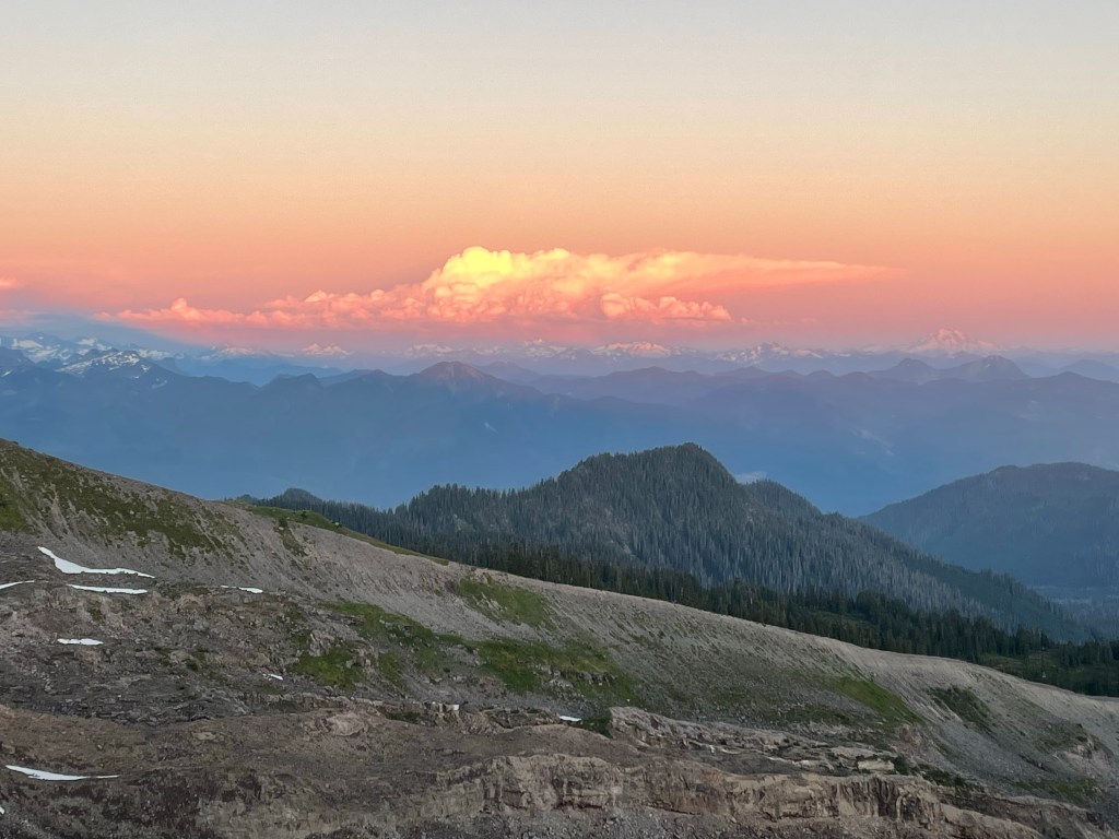
After we settled in, we had a dinner of Mac’n cheese and smoked salmon and hiked up to a nearby bluff to see a spectacular sunset. On one side are the majestic mountains of the Cascades, on the other, the glassy ocean with Vancouver Island in the background. The setting sun backlit the clouds and snow capped mountains turning everything a soft apricot. It was a good omen for the next day and our upcoming summit attempt.

Spectacular photo!
LikeLiked by 1 person